Geophyical Survey: Bamburgh Castle Environs

In early 2023 the BRP was awarded funding from the Castle Studies Trust to undertake a series of non-invasive surveys to provide additional context to the outworks of Bamburgh Castle, focussing on St Oswald’s Gate and the Tower of Elmund’s Well. You can find out more about this area in our earlier blog posts (here’s a good place to start: Director’s End of Season Excavation Round-up).

We are now finalising the associated reports and sharing these ahead of releasing our interim excavation report. The next report we are sharing details a geophysical survey that we undertook with Dr Kristian Strutt of the Archaeological Prospection Services Southampton University exploring the environs of Bamburgh Castle.
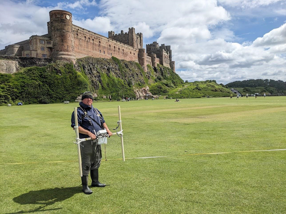
Person stood on large grassy area in front of large castle situated on rock promontory. Man is holding a white twin probe device with computer attached in middle

Dominic Barker using the Bartington Grad 601-2 instrument on the Cricket Ground (photo: K. Strutt)

The Geophysical Survey Results

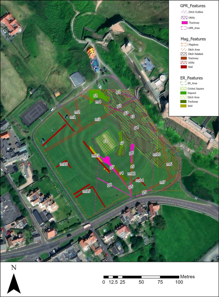
The survey utilised magnetometry, resistivity and Ground Penetrating Radar (GPR) survey of areas of the Cricket Ground to the west of Bamburgh Castle. The results indicate the possible presence of a large ditch, some 45m across, immediately to the west of the outcrop, in addition to trackways, walls and other features in the survey area.

One of the principal questions we were hoping to address with the geophysics was if the castle ditch extended across the sports field at the base of the castle rock. A ditch cut through sandstone, can been traced in the area of the modern entrance that is at the site of the 12th century gate. This feature extends across the front of the castle as far as the sandstone ridge was present above ground. The results of the GPR do seem to strongly indicate a large feature in the area where we would anticipate the castle ditch to be and the magnetometry and resistance surveys do seem to support this. It is intended to conduct further fieldwork, starting with coring, to confirm this.
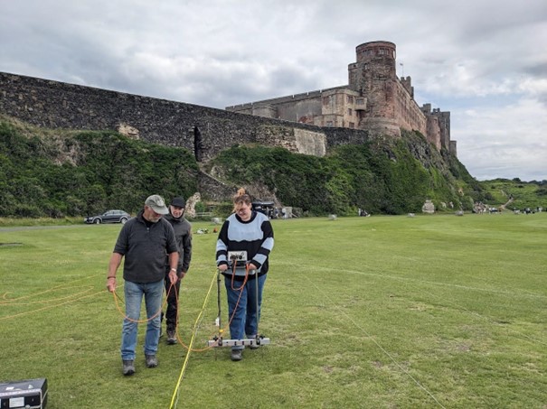
Three people stood on large grassy area in front of large castle situated on rock promontory. Person is holding a white twin probe device with computer attached in middle with wires hanging down

Earth resistance survey being carried out by BRP volunteers (photo: K. Strutt)

In addition, to the probable ditch feature, several features seen on the 1st Edition Ordnance Survey appear to be picked up on the surveys. Two trackways are evident, that lead to St Oswald’s Gate and to a cleft in the castle rock called the ‘Miller’s Nick’, which allowed people to scramble up to the West Ward in the 19th century. The second is an S-shaped path that meandered towards the area of St Oswald’s Gate, perhaps originally skirting around the edge of the ditch feature. One further route-way or path extends across the field parallel to the road in the village to the south, called the Wynding, that appears from records to have had a medieval origin. This path runs alongside a linear plot boundary and field boundaries and it will be interesting to see if more can be made from a number of anomalies that can be seen within the enclosure areas to the south and west of the plot.

The resistivity and ground penetrating radar surveys so far cover a more limited area, due to time constraints and public access. There is an area of low resistance that lies in just the area that the ditch would lie and matches up to the path towards the Miller’s Nick. The enclosure areas picked up in the magnetometry to the south-west also seems to be present on the resistivity. Notably, there is a high resistance feature that the S-shaped pathway may curve deliberately to avoid at the south part of the plot. A further T-shaped high resistance feature is present in the north-east extending from the area of the modern pavilion that will bear further study. The GPR further reinforces the presence of some of these features and indicates some depth to the anomaly that is interpreted as the ditch, though the signal attenuates before it could indicate a true depth.

Aerial image of the castle and surrounding landscape with overlays of each survey depicting where features have been found. Map key to the right.

Interpretation plot of all three surveys, labels link to the report text (Airbus 11/05/23)


Download the Full Report

If you want to take a deeper dive into the results of the geophysical survey you can download the report here: Report on the Geophysical Survey at Bamburgh, Northumberland, July 2023

It provides more information about the background to the site, detail about each survey technique and a breakdown, with useful maps and figures, about what was discovered.

In our forthcoming interim report we use this information to enhance our understanding of the castle within its landscape context and explore in more detail what some of the features identified in the survey might be.


The geophysical survey described in this blog has been funded by the Castle Studies Trust.

This charity is entirely reliant on donations from the public. To help the Trust to continue funding this kind of research, please visit https://www.castlestudiestrust.org/Donate

To find out more about the Trust please visit www.castlestudiestrust.org

Photogrammetry Survey of Bamburgh Castle’s Medieval Outworks: St Oswald’s Gate and the Tower of Elmund’s Well.

In early 2023 the BRP was awarded funding from the Castle Studies Trust to undertake a series of non-invasive surveys to provide additional context to the outworks of Bamburgh Castle, focussing on St Oswald’s Gate and the Tower of Elmund’s Well. You can find out more about these in our earlier blog posts (here’s a good place to start: Director’s End of Season Excavation Round-up).

We are now in the process of finalising the associated reports and outputs and will be sharing these over the next few weeks ahead of releasing our interim excavation report. One of the surveys we undertook was a preliminary assessment of the standing masonry elements in the outworks, which will sit alongside the excavated archaeological report. To support this we also commissioned several photogrammetry surveys to create 3D models of the standing outworks and internal structures of the Tower of Elmund’s Well.

We are really excited to be able to share these with you now. Below, you can click each photo to take you to the online model, which will allow you to explore each area in detail.

3D Models of Bamburgh Castle’s Northern Outworks 2023

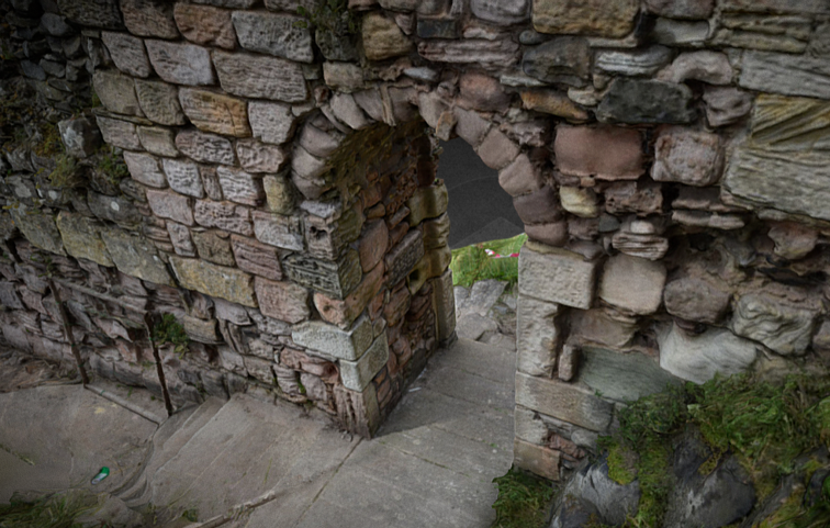
3D Model of Crosswall with St Oswald’s Gate

St Oswald’s Gate is written about as the entrance to the fortress of Bamburgh in the 8th century AD (Symeon HK, III. pg 37) and was very likely the route up onto the rock plateau since the earliest settlements. The present phase of work is investigating the entrance, the access routes up to the entrance and the structures and outworks built to control this route over many generations.


3D Model of The Tower of Elmund’s Well

One particular area of focus was the recovery of the site of the Tower of Elmund’s Well, named in records from the 13th century (Colvin, H. M. pg 556) and onto which a cottage was constructed in the late 18th century.

The outline of the cottage/tower structure was quickly revealed during the first phase of investigation by the removal of foliage and a modest volume of aeolian sand. One of the first exciting discoveries during 2022 excavation was the presence of two splayed lights (open window-like features) in two of the walls. The discovery of the top of a stone archway that formed the entrance to the well-room confirms both the depth of the basement, there must after all be depth to pass under the arch, but also suggest that the floor level cannot be too much deeper.


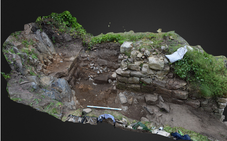
3D Model of the Postern Gate Trench 5D

The postern gate lies beyond St Oswald’s Gate and leads out to Bamburgh Village. The structure as uncovered was a single well-constructed feature of coursed squared masonry that ended abruptly and deliberately short of the rock. A further constructed face abutted the bedrock and the gap between the two faces a little more than 1m side formed what surely must have been a second gate.


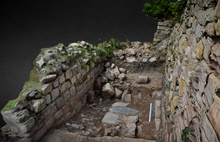
3D Model of Trench 5E with possible foundation wall

Trench 5E was a new trench opened in 2023, sited outside of the wall with the postern gate and the outworks. It was placed next to a short length of wall that we investigated in 2022 to see if it had once extended further. It has revealed a stone alignment that extends parallel to the two standing walls. Those of the outworks and the short wall length. So far only the upper level has been uncovered, so it is possible that it could be either a wall top or a foundation or the surface of a narrow path.


We think being able to share these 3D models, alongside the traditional interim report, really helps others who have not been to site to visualise the structures and our progress to date.

Please check back soon to take a look at the preliminary masonry report that will add further detail to the 3D models above.


Book Now for our 2023 Post-Excavation Week!

Dates: 10th-14th September 2023


Bookings are OPEN for a 1 week post-excavation taster.


Two people sorting finds from the environmental flotation system
Participant recording artefacts

What is post-excavation?

Archaeology is not all about digging. In order to turn the data gathered through excavations or surveys (for example) into information that can be used to interpret a site and/or plan further investigations, archaeologists must process this data during the ‘post-ex’ phase.

This includes recording the artefacts recovered, processing the environmental samples taken, digitising the drawings and survey information, for example. This work generates a physical and digital archive, which connects all the pieces of information together. It takes far longer (in most cases) than the actual field work and often takes place in the lab or at the desk.

Post-Ex at the Bamburgh Research Project

Here at the BRP we have generated a lot of post-excavation work in the last 20 years. We undertake much of the initial post-ex on site, where we wash and process the small and bulk finds, we process our environmental samples and we catalogue much of the records and photographs we take. However, there is still much work that is undertaken during the off-season by our staff and more that is sent away for specialist analysis. We thought this year we might bring some of this ‘behind the scenes’ work back to the Castle and share it with a small cohort of interested individuals.


What is the Post-Excavation Taster Week?

We offer quality training in archaeology with an emphasis on practical hands-on experience. The post-excavation taster week will use the BRP’s extensive archive, which consists of material from the prehistoric to the medieval periods, as the basis for an introduction to the different post-excavation techniques and research methodologies employed by the project.

We are still planning the daily schedule but the week will include:

Please Note: we are also in the process of organising a visits by a conservator and/or osteoarchaeologist but these are yet to be confirmed.


Who is it for?

Our training is open to people of all skill-levels and abilities, with particular interests accommodated where possible. We particularly wish to offer a fun and educational experience to beginners and non professionals.

Please get in touch with us if you have any questions about access, facilities, etc.

BRP is open to anyone aged 18 and over. 

Who will be teaching me?

Professional field archaeologists and post-excavation specialists.

How much does it cost?

The post-excavation taster week costs £300 pp and covers 5 days of training in a small group of between 6-8 people. This covers the cost of the tuition, tours and the trip to Lindisfarne.


How do I book a place?

Please visit the BRP’s website and take a look at the Post-Ex Taster Week page. At the end of the page is the details on how to book and pay for your place.

PLEASE NOTE: the week will only run if the BRP receive enough bookings to make the week viable (more info on website).

Any questions? Email: graemeyoung@bamburghresearchproject.co.uk

Funding Success for the Bamburgh Research Project with the Castle Studies Trust

The Bamburgh Research Project (BRP) are pleased to announce that we have been successful in securing £9306 from the Castle Studies Trust (CST).
Over the next 12 months the BRP will be utilising the funding to further explore Bamburgh Castle’s medieval outworks, particularly the area outside St Oswald’s Gate where our current excavation is underway as part of our annual field school. Our project is titled ‘Contextualising Bamburgh Castle: wells, towers, mounds and more!’

St Oswald’s Gate and the Medieval Outworks

St Oswald’s Gate and the outworks beyond lie in the area of the original entrance to the castle. It is very likely that the siege castle (named Mal Voisin in the Anglo-Saxon Chronicle) was built close to this gate in AD 1095. When the main access was re-sited, the entrance here remained as an important postern. Perhaps serving a small adjacent harbour immediately to the north of the site. This area now forms the BRP’s main investigative focus. The outworks consist of strong walls enclosing a trapezoidal area with the Tower of Elmund’s Well. With a more recent wall and postern to the west.

The outworks at St Oswald’s Gate are a rare case at Bamburgh as they have not been subject to extensive rebuilding in the post medieval period. Other than the reconstruction of the tower as a cottage, the outworks represent an astonishing window into mostly unaltered medieval fabric still standing at Bamburgh.

Foreground shows the area currently under excavation by the BRP with St Oswald’s Gate visible at the top of the steps and West Ward of Bamburgh Castle present in the background.

Work to Date

Recent investigation by the BRP has revealed that a substantial structure still survives below ground. This is in the form of an L-shaped corridor and steps down into the room that is thought to be the tower basement that contained the well. The presence of two splayed narrow windows appears to further indicate that this is part of the medieval Elmund’s Tower. The 2023 excavation season aims to reveal the full extent of the tower and identify any remains of the well depicted on the 19th century survey. You can find out more about our ongoing excavations in this area by taking a look at earlier blog posts: Investigations beyond St Oswald’s Gate: End of Season Overview.

What will the CST Funding be used for?

There are two primary aims for the CST funding. The first is to contextualise our recent excavations at Elmund’s Tower through geophysical survey (GPR and Magnetometry) and undertake a preliminary masonry survey of the castle’s associated extant outworks.

The geophysical survey will provide context to the area immediately outside of the outworks and identify if the castle ditch (seen as a rock cut feature at the Great Gate) extends all the way along the front of the castle. As part of the masonry survey the project will be using photogrammetry to create a 3D model of the standing outworks and internal structures of Elmund’s Tower. The survey will be undertaken in conjunction with a metric survey of the structures outlines so that a photo-real, stone by stone, 3D photo model can be used as a management tool for future plans, including consolidation work.

The investigation of the area will be used to aid in making management decisions to ensure the preservation of the outworks. More broadly, the proposed investigations will assist the interpretation of the extensive, but more complex and disturbed stratigraphical sequences recovered elsewhere in the castle, principally the West Ward.

We will also be using the photogrammetry and geophysical surveys as an opportunity to upskill BRP staff and provide add-on benefits to students during our annual field school (July 2023).

The second focus for the funding will be on disseminating our discoveries to the wider public. Bamburgh Castle is in the process of re-focussing the story it tells the public, giving greater focus to its medieval and early medieval history through a new website, signage throughout the grounds and new displays within the castle itself. However, the medieval outworks are inaccessible to the public and there is currently no opportunity to highlight the ongoing research into this area of the castle and how the site was shaped by the surrounding topography. The funding will allow us to create and install signage for visitors with a QR code for the 3D model, granting online access to Elmund’s Tower and the wider outworks. This information will also be replicated and enhanced with the creation of a new webpage on the Bamburgh Castle website. Alongside these permanent additions we will continue to share our work through our blog and social media.

Listen to two of our Directors discuss the project with the CST

Project Directors, Jo Kirton and Graeme Young, recently spoke to the CST about the project, which you can listen to here:

Make sure you follow our blog and social media accounts to see how the project progresses over the summer. We cannot wait to share what we discover!

Introducing our Newest Director….

We are really pleased to introduce our newest Director, Constance Durgeat!!!

Many of you will know Constance as she has been with the project since 2010 and many more will recognise her from our social media and blogs. Constance has been an amazing team member and over the past few years she has managed our excavations at the castle and looked after everyone off site.

Constance first joined the Bamburgh Research Project as an undergrad student in Art History and Archaeology from the Sorbonne University in Paris. After a Masters’ in Urban Archaeology, she moved to York to complete a Masters on Bamburgh’s metalworking area in Trench 3. She was then made supervisor of Trench One and carried out more roles over the years.

For Constance, coming from France where community archaeology does not really exist, it was (and still is) very exciting to get to teach anyone, no matter their level or education! Thanks to this interest, she has worked for seven years with the University of York, teaching first-year students fieldwork techniques and environmental processing. She has worked with multiple commercial companies, digging a variety of sites across England to keep her skills up to date. She now works as a Senior Archaeology Consultant with Rocket Heritage and Archaeology. Her main interests are Anglo-Saxon and medieval archaeology and buildings archaeology.…and travelling around the world when she has time!

Introduction to Archaeological Finds a Post Excavation Taster Week: Bookings Open Now!!!

Dates: 10th-14th September 2023


Bookings are OPEN for a 1 week post-excavation taster.


Two people sorting finds from the environmental flotation system
Participant recording artefacts

What is post-excavation?

Archaeology is not all about digging. In order to turn the data gathered through excavations or surveys (for example) into information that can be used to interpret a site and/or plan further investigations, archaeologists must process this data during the ‘post-ex’ phase.

This includes recording the artefacts recovered, processing the environmental samples taken, digitising the drawings and survey information, for example. This work generates a physical and digital archive, which connects all the pieces of information together. It takes far longer (in most cases) than the actual field work and often takes place in the lab or at the desk.

Post-Ex at the Bamburgh Research Project

Here at the BRP we have generated a lot of post-excavation work in the last 20 years. We undertake much of the initial post-ex on site, where we wash and process the small and bulk finds, we process our environmental samples and we catalogue much of the records and photographs we take. However, there is still much work that is undertaken during the off-season by our staff and more that is sent away for specialist analysis. We thought this year we might bring some of this ‘behind the scenes’ work back to the Castle and share it with a small cohort of interested individuals.


What is the Post-Excavation Taster Week?

We offer quality training in archaeology with an emphasis on practical hands-on experience. The post-excavation taster week will use the BRP’s extensive archive, which consists of material from the prehistoric to the medieval periods, as the basis for an introduction to the different post-excavation techniques and research methodologies employed by the project.

We are still planning the daily schedule but the week will include:

Please Note: we are also in the process of organising a visits by a conservator and/or osteoarchaeologist but these are yet to be confirmed.


Who is it for?

Our training is open to people of all skill-levels and abilities, with particular interests accommodated where possible. We particularly wish to offer a fun and educational experience to beginners and non professionals.

Please get in touch with us if you have any questions about access, facilities, etc.

BRP is open to anyone aged 18 and over. 

Who will be teaching me?

Professional field archaeologists and post-excavation specialists.

How much does it cost?

The post-excavation taster week costs £300 pp and covers 5 days of training in a small group of between 6-8 people. This covers the cost of the tuition, tours and the trip to Lindisfarne.


How do I book a place?

Please visit the BRP’s website and take a look at the Post-Ex Taster Week page. At the end of the page is the details on how to book and pay for your place.

PLEASE NOTE: the week will only run if the BRP receive enough bookings to make the week viable (more info on website).

Any questions? Email: graemeyoung@bamburghresearchproject.co.uk

Week 4 Round-up

This week included a lot of recording and sorting, some massive earth-moving, and preparing to leave site!

We digitised a bunch of plans and context sheets, and we also continued monitoring the finds in the archive annex and updating the database with location information.

We were so grateful to have friends of the project get those incredible drone photos for us on Tuesday. You can see some sneak peeks here.

A very excited trench team looking at the drone photographs.

Some interesting finds came out in all the processing, such as the yellow glass bead and bone pin below. The bead came from an environmental sample taken in 2013 of 9th/10th-century context; multiple 2013 samples run this season also produced several other beads, but all but one of those were ceramic (the other a crinoid fossil, “Saint Cuthbert’s bead”). The bone pin is from a context tray from Trench 5c that we looked at today before organising storage. It was from an area of the long stretch of medieval wall where we had previously only been finding modern material, until we extended the trench (see below).

In the trenches, we moved so much earth!

First, we extended the old 2002 trench along the longest stretch of standing wall which we are calling Trench 5c. The extension was to learn more about the rubble that is scattered perpendicular to the face. Some of the stone positions suggest that another wall came out of the length we still have.

Then, we fully exposed a large stone surface abutting the dolerite up at the postern gate trench we called Trench 5d. It’s not clear exactly what was happening, and we thought bringing down the inner face would answer our questions. It only gave us more questions! Two large stones with tool marks appear to have fallen down into the northern end of the trench. On the southern side of the trench, a large spread of mortar appeared.

Thursday was the big day of rubble-removal with the help of Stuart and Steve from the Castle team. We would bet at least a [literal] tonne of rock was removed. On Friday, the well-room was cleared of the big stones, so we mattocked and shoveled as much soil as we could. We also cleaned off the steps! Finally, we photographed the steps and well-room even though both are not yet completely excavated.

It’s our last day on-site this season, so we wanted to let you know about what to expect in the off-season:

At least two blog posts will be headed your way in the next few weeks. First, Alice will be providing an update on the environmental assemblage and what it tells us about cereals at Bamburgh during the early medieval period. Then Graeme will do his usual end-of-season post with a round-up and tentative interpretations, plus some thoughts on our next steps.

Please also keep an eye out for news regarding our publication of the Bowl Hole research!

As always, follow us on social media for the latest information on our research and upcoming field school opportunities. That’s all for now, but you will definitely see us next year, back in the outworks!

Geoarchaeology at the Bradford Kaims

Becky Scott – Assistant Supervisor (Geoarcheology) and PhD Candidate, University of Reading

Following on from our blog post about the geophysical survey carried out at the Kaims this year, we have been busy ‘ground-truthing’ the anomalies seen just to the North of Trench 6 – that is, identifying whether the magnetic anomalies seen on the survey are archaeological features or not. Of course, like most endeavors, we have had varying degrees of success! The first few test pits that were dug contained nothing but colluvium (sediment that has been deposited downslope, often known as hill or slope wash) even after digging up to a metre. We then decided to take some cores around the area that showed the magnetic anomalies to the North of Trench 6 using the Dutch auger, which is essentially a long pole about 1 metre long with a T-handle and a screw-like head at the bottom which collects and retains sediment. Dutch augers are particularly useful for hard and wet sediments so worked very well through our silty clay colluvium. After taking a number of cores (with the excellent help of our two Young Archaeologists Club competition winners!) we eventually came up with some lovely layers of charcoal and burnt material, so we set to work digging three more test pits. Two of these test pits were more much more successful, particularly Test Pit 75 which showed a charcoal layer almost 30cm thick (see Figure 1 below).

Figure 1

Figure 1. SE-facing section of TP75 showing three very distinct layers: Top soil, colluvium and a ~30 cm thick charcoal and stone rich layer.

 Test Pits in the wider landscape

As well as ground-truthing the results of the geophysical survey, we have also been collecting samples for geoarchaeological analysis from some larger test pits dug by our new friend, The Big Digger. For those unfamiliar, geoarchaeology is an approach to archaeology which utilises techniques from the earth and environmental sciences to answer archaeological questions. In real life it mostly involves getting really, really muddy and pondering sediment sequences for long periods of time…

The main aim was to take samples from the colluvium in the wider landscape (identified during coring by Dr. Richard Tipping and Coring Supervisor Anna) for radiocarbon and pOSL (portable Optically Stimulated Luminescence) dating and micromorphology (the study of in-situ soils and sediments in thin section) to provide us with a proxy for human activity in the immediate area (see Figure 2 below). Colluvium results from human activity, particularly agriculture, and therefore can tell us about past agricultural processes in the wider landscape as it represents a period of soil erosion due to ploughing, over-grazing, and the removal of trees. Under gravity these sediments are then transported downslope. Sometimes, if geoarchaeologists are lucky, ancient soils will be preserved underneath the colluvium allowing us to infer a period of stability and identify the environmental conditions before the land was cleared. The nature of the colluviation also gives information about what processes caused it to erode, and how high the energy of its erosion was.

Figure 2

Figure 2. Students Oda and Daniel taking OSL samples in the extended section of T6 with Anna and Becky, and Director Paul also working hard in the background. Samples for pOSL were taken vertically down the sequence from the section by inserting tubes into the face of the section, removing gently and quickly securing with tape to ensure no light entered the samples. They were then labelled with a sample number and an arrow indicating the end that had not been exposed to light, ready for laboratory analysis.

Figure 2. Students Oda and Daniel taking OSL samples in the extended section of T6 with Anna and Becky, and Director Paul also working hard in the background. Samples for pOSL were taken vertically down the sequence from the section by inserting tubes into the face of the section, removing gently and quickly securing with tape to ensure no light entered the samples. They were then labelled with a sample number and an arrow indicating the end that had not been exposed to light, ready for laboratory analysis.

pOSL will hopefully allow us to identify the rates of erosion in the area, with the radiocarbon dates from the peat below effectively acting as an ‘anchor’ to identify when this erosion (and therefore agricultural clearance) began. Once the thin sections are made, micromorphology will allow us to identify the depositional and post-depositional processes occurring at the microscale.

Geomorphological Survey at the Bradford Kaims

 Anna Finneran, Coring Supervisor and PhD Candidate, University of Durham

In 2017 the Kaims coring team has benefitted from many dry days, and persevered through some soaking days. Here’s a quick update on the accomplishments of Dr. Richard Tipping and field school students this season:

The Bradford Kaims branch of the BRP since 2010 has conducted a landscape-scale interdisciplinary investigation of a large fenland associated with our archaeological sites.  Excavations have uncovered multiple burnt mounds, structural remains, and artefacts.  Human activity spans at least the Mesolithic through the Bronze Age.  The features and material culture represent an industrial area.  Conspicuous in its absence, however, is evidence for domestic activity in the landscape. In contrast, palaeoenvironmental reconstructions present a rich aquatic environment, characterised by two large lakes throughout the Holocene and populated with unique flora and fauna, potentially attractive for long-term habitation.  The landscape surveys this season have sought to look beyond the Neolithic and Bronze Age by incorporating geomorphology, geophysics, soil micromorphology, and excavation to describe both the natural landscape and the human activity throughout the Holocene.

The main aim of the 2017 season in terms of this geomorphological mapping was coring and sediment description at locations known to contain or likely to contain layers of colluvial accumulation (or slopewash). Colluvial accumulation would result from episodes of erosion on slopes descending towards the fenland basin. Geomorphological analyses from previous seasons concluded that no natural sediment erosion occurred on steep slopes around the fenland. Any erosion on gentler slopes may then be ascribed to archaeological, and potentially agricultural, activity.

The coring team conducted coring transects across the landscape, inserting a metal tube (or sediment core) into the soils and sediments of the fenland and its surrounds, to chart the different types and depths of material.  We successfully identified layers of colluvium within layers of peat, representing episodes of agricultural destabilisation of the slopes, at numerous points. Following reconnaissance, five locations were selected for a combination of analyses including soil micromorphology and pOSL analysis (see Becky Scott’s blog in a few days for more detail on this!).

Another aim of the geomorphological investigations in 2017 was working in tandem with Graeme Attwood’s magnetometry survey to define buried anomalies. Coring and sediment description preceded excavation of 1 x 1m test pits over the most promising anomalies. The anomalies to the NW of Trench 6 proved to be burnt mounds, as hoped. However, the anomalies in the form of two parallel lines between Trenches 11 and 9 were found to be ditches for Victorian age drainage pipes.

Richard

Despite our pipe-related set-backs, one lost (but later retrieved) core, and numerous small injuries and sprains, the coring team successfully completed our aims for this season with positive and encouraging results for the future. Next season we hope to continue to investigate the natural landscape and the human impact upon the environment throughout the Holocene, and hopefully use the analyses of colluvial deposits and the dating material provided by the fenland to gain a more in-depth understanding of how people across the Bronze Age and Iron Age influenced their landscape.

Archaeomagnetic Studies at the Bradford Kaims

Archmag

Sam Harris, Doctoral Research Student – University of Bradford

Firstly, it is purely coincidental that I study in Bradford (West Yorkshire) and am coming to take samples at the Bradford Kaims. As an archaeomagnetist, and we are pretty few and far between, it is always amazing the variety of sites that you get to see and work on. Having parachuted into the Bradford Kaims trenches for the second time, this site is no exception in its wonder. Placed at the edge of a fen, the variety of soil and sediment types on site is impressive! This offers the perfect opportunity for archaeomagnetic studies.

For those that aren’t quite sure what this odd science (magic) is, you are welcome to peruse my website, which is listed at the end of this blog post, for some answers. Simply put, the Earth has a magnetic field which varies over space and time. A record of the past geomagnetic field can be found in the in situ remains of hearths, furnaces, or other anthropogenically fired features that we as archaeologist excavate on a regular basis. Archaeomagnetic studies seek to improve our knowledge of past geomagnetic field changes through the analysis of this material. Why though, I hear you ask…

This is because we can use the knowledge of geomagnetic fluctuations over time to conduct archaeomagnetic dating and gain an idea of the last time that some fired archaeological features were heated. Having a dating method which directly relates to an anthropogenic activity, rather than to the end of an organism’s carbon absorption for example, is a powerful tool for the archaeologist.

Archaeomagnetic dating was first attempted at the Bradford Kaims in 2011. While the study was successful and the date recovered for a fired hearth feature in Trench 6 (c.4350 cal.BC) was considered accurate given other artefactual dating evidence for the site, newly acquired radiocarbon dating evidence suggests that the calibration methods used for the archaeomagnetic dates produced erroneous results. This was due to the use of an experimental and alternative calibration model from outside the UK, as the current UK calibration model does not stretch back into the Bronze Age or before. This previous study, and others since, have identified the need for further work to be undertaken. This is where me and my PhD come in! My main aim is to improve our understanding of geomagnetic field change during prehistoric periods, but particularly the Neolithic.

At the Bradford Kaims this season, I sampled two features associated with the Bronze Age burnt mounds, both of them interpreted as fire pits containing fired stones, burnt sediments, ash, and charcoal. These features will provide good radiocarbon dating records, alongside the archaeomagnetic signatures for the fired subsoils within and below them.

Thanks to the Bamburgh Research Project’s excellent radiocarbon dating programme at the Bradford Kaims, the fired archaeological features that I can archaeomagnetically study will have independent dates associated with them. By building up a number of well-dated features in this way, a new calibration curve for the UK can be created, with the Bradford Kaims being a central case study in this process. Through the combined use of radiocarbon dating and archaeomagnetic dating on prehistoric sites like the Bradford Kaims, we can gain a more nuanced understanding of their chronologies.

Sam’s website can be viewed at; www.neolithicarchaeomagnetism.weebly.com

Sam’s Twitter can be viewed at; @Archaeomagnetic