Geophyical Survey: Bamburgh Castle Environs

In early 2023 the BRP was awarded funding from the Castle Studies Trust to undertake a series of non-invasive surveys to provide additional context to the outworks of Bamburgh Castle, focussing on St Oswald’s Gate and the Tower of Elmund’s Well. You can find out more about this area in our earlier blog posts (here’s a good place to start: Director’s End of Season Excavation Round-up).

We are now finalising the associated reports and sharing these ahead of releasing our interim excavation report. The next report we are sharing details a geophysical survey that we undertook with Dr Kristian Strutt of the Archaeological Prospection Services Southampton University exploring the environs of Bamburgh Castle.
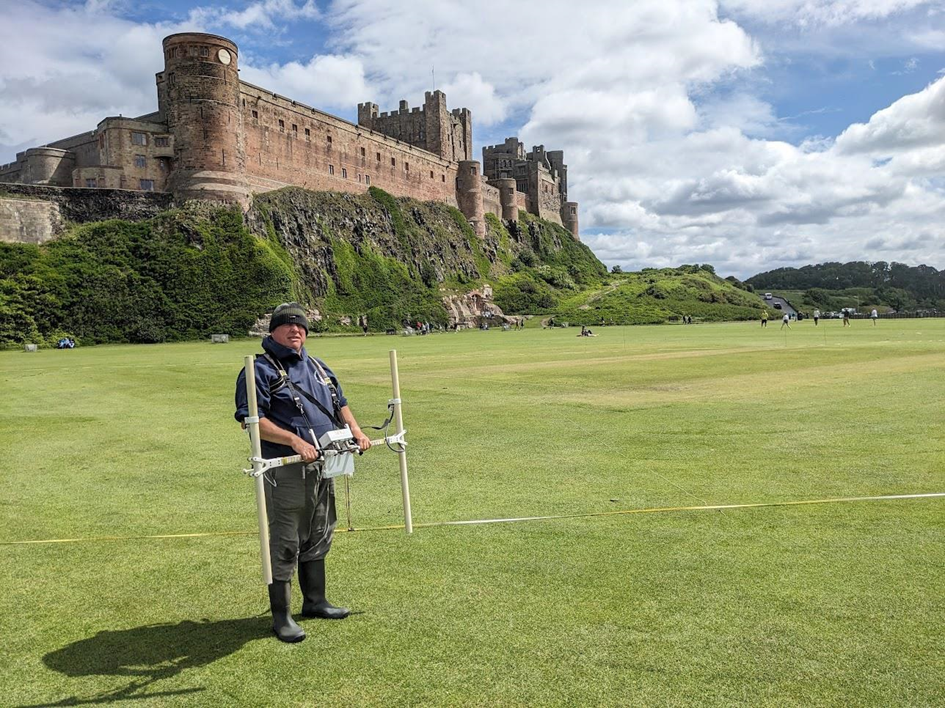
Person stood on large grassy area in front of large castle situated on rock promontory. Man is holding a white twin probe device with computer attached in middle

Dominic Barker using the Bartington Grad 601-2 instrument on the Cricket Ground (photo: K. Strutt)

The Geophysical Survey Results

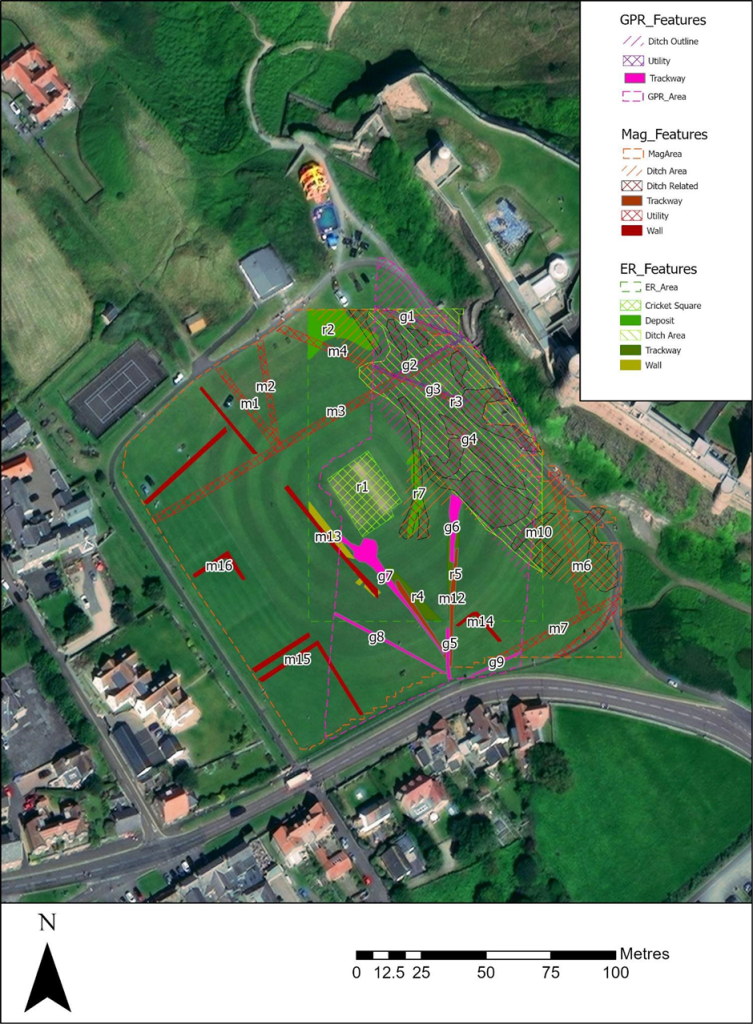
The survey utilised magnetometry, resistivity and Ground Penetrating Radar (GPR) survey of areas of the Cricket Ground to the west of Bamburgh Castle. The results indicate the possible presence of a large ditch, some 45m across, immediately to the west of the outcrop, in addition to trackways, walls and other features in the survey area.

One of the principal questions we were hoping to address with the geophysics was if the castle ditch extended across the sports field at the base of the castle rock. A ditch cut through sandstone, can been traced in the area of the modern entrance that is at the site of the 12th century gate. This feature extends across the front of the castle as far as the sandstone ridge was present above ground. The results of the GPR do seem to strongly indicate a large feature in the area where we would anticipate the castle ditch to be and the magnetometry and resistance surveys do seem to support this. It is intended to conduct further fieldwork, starting with coring, to confirm this.
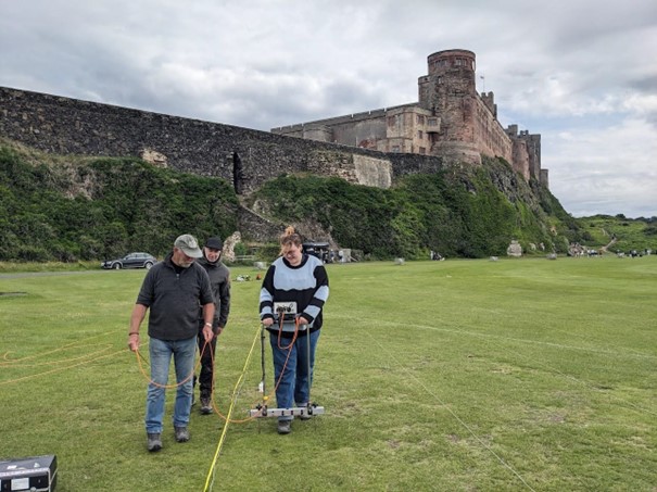
Three people stood on large grassy area in front of large castle situated on rock promontory. Person is holding a white twin probe device with computer attached in middle with wires hanging down

Earth resistance survey being carried out by BRP volunteers (photo: K. Strutt)

In addition, to the probable ditch feature, several features seen on the 1st Edition Ordnance Survey appear to be picked up on the surveys. Two trackways are evident, that lead to St Oswald’s Gate and to a cleft in the castle rock called the ‘Miller’s Nick’, which allowed people to scramble up to the West Ward in the 19th century. The second is an S-shaped path that meandered towards the area of St Oswald’s Gate, perhaps originally skirting around the edge of the ditch feature. One further route-way or path extends across the field parallel to the road in the village to the south, called the Wynding, that appears from records to have had a medieval origin. This path runs alongside a linear plot boundary and field boundaries and it will be interesting to see if more can be made from a number of anomalies that can be seen within the enclosure areas to the south and west of the plot.

The resistivity and ground penetrating radar surveys so far cover a more limited area, due to time constraints and public access. There is an area of low resistance that lies in just the area that the ditch would lie and matches up to the path towards the Miller’s Nick. The enclosure areas picked up in the magnetometry to the south-west also seems to be present on the resistivity. Notably, there is a high resistance feature that the S-shaped pathway may curve deliberately to avoid at the south part of the plot. A further T-shaped high resistance feature is present in the north-east extending from the area of the modern pavilion that will bear further study. The GPR further reinforces the presence of some of these features and indicates some depth to the anomaly that is interpreted as the ditch, though the signal attenuates before it could indicate a true depth.

Aerial image of the castle and surrounding landscape with overlays of each survey depicting where features have been found. Map key to the right.

Interpretation plot of all three surveys, labels link to the report text (Airbus 11/05/23)


Download the Full Report

If you want to take a deeper dive into the results of the geophysical survey you can download the report here: Report on the Geophysical Survey at Bamburgh, Northumberland, July 2023

It provides more information about the background to the site, detail about each survey technique and a breakdown, with useful maps and figures, about what was discovered.

In our forthcoming interim report we use this information to enhance our understanding of the castle within its landscape context and explore in more detail what some of the features identified in the survey might be.


The geophysical survey described in this blog has been funded by the Castle Studies Trust.

This charity is entirely reliant on donations from the public. To help the Trust to continue funding this kind of research, please visit https://www.castlestudiestrust.org/Donate

To find out more about the Trust please visit www.castlestudiestrust.org

Post-Excavation Taster Weeks -Booking Now Open

Dates: May 20th to 24th and September 9th to 13th

What is post-excavation?

Archaeology is not all about digging. In order to turn the data gathered through excavations or surveys (for example) into information that can be used to interpret a site and/or plan further investigations, archaeologists must process this data during the ‘post-ex’ phase.

This includes recording the artefacts recovered, processing the environmental samples taken, digitising the drawings and survey information, for example. This work generates a physical and digital archive, which connects all the pieces of information together. It takes far longer (in most cases) than the actual field work and often takes place in the lab or at the desk.

Post-Ex at the Bamburgh Research Project

Here at the BRP we have generated a lot of post-excavation work in the last 20 years. We undertake much of the initial post-ex on site, where we wash and process the small and bulk finds, we process our environmental samples and we catalogue much of the records and photographs we take. However, there is still much work that is undertaken during the off-season by our staff and more that is sent away for specialist analysis. We thought this year we might bring some of this ‘behind the scenes’ work back to the Castle and share it with a small cohort of interested individuals.


What is the Post-Excavation Taster Week?

We offer quality training in archaeology with an emphasis on practical hands-on experience. The post-excavation taster week will use the BRP’s extensive archive, which consists of material from the prehistoric to the medieval periods, as the basis for an introduction to the different post-excavation techniques and research methodologies employed by the project.

We are still planning the daily schedule but the week will include:

Please Note: we are also in the process of organising tuition by an osteoarchaeologist for September TBC.


Who is it for?

Our training is open to people of all skill-levels and abilities, with particular interests accommodated where possible. We particularly wish to offer a fun and educational experience to beginners and non professionals.

Please get in touch with us if you have any questions about access, facilities, etc.

BRP is open to anyone aged 18 and over. 

Who will be teaching me?

Professional field archaeologists and post-excavation specialists.

Learn about ancient textiles

How much does it cost?

The post-excavation taster week costs £350 pp and covers 5 days of training in a small group of between 6-8 people. This covers the cost of the tuition, tours and the trip to Lindisfarne.


How do I book a place?

Please visit the BRP’s website and take a look at the Post-Ex Taster Week page. At the end of the page is the details on how to book and pay for your place.

PLEASE NOTE: the week will only run if the BRP receive enough bookings to make the week viable (more info on website).

Any questions? Email: graemeyoung@bamburghresearchproject.co.uk

Photogrammetry Survey of Bamburgh Castle’s Medieval Outworks: St Oswald’s Gate and the Tower of Elmund’s Well.

In early 2023 the BRP was awarded funding from the Castle Studies Trust to undertake a series of non-invasive surveys to provide additional context to the outworks of Bamburgh Castle, focussing on St Oswald’s Gate and the Tower of Elmund’s Well. You can find out more about these in our earlier blog posts (here’s a good place to start: Director’s End of Season Excavation Round-up).

We are now in the process of finalising the associated reports and outputs and will be sharing these over the next few weeks ahead of releasing our interim excavation report. One of the surveys we undertook was a preliminary assessment of the standing masonry elements in the outworks, which will sit alongside the excavated archaeological report. To support this we also commissioned several photogrammetry surveys to create 3D models of the standing outworks and internal structures of the Tower of Elmund’s Well.

We are really excited to be able to share these with you now. Below, you can click each photo to take you to the online model, which will allow you to explore each area in detail.

3D Models of Bamburgh Castle’s Northern Outworks 2023

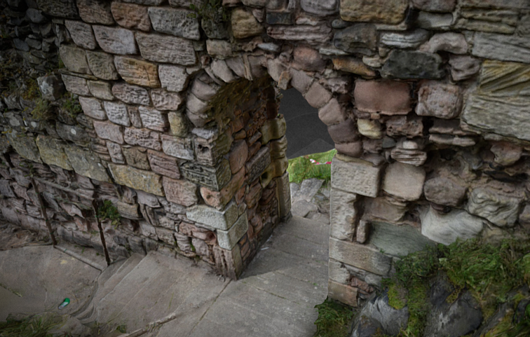
3D Model of Crosswall with St Oswald’s Gate

St Oswald’s Gate is written about as the entrance to the fortress of Bamburgh in the 8th century AD (Symeon HK, III. pg 37) and was very likely the route up onto the rock plateau since the earliest settlements. The present phase of work is investigating the entrance, the access routes up to the entrance and the structures and outworks built to control this route over many generations.


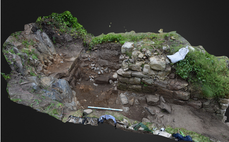
3D Model of The Tower of Elmund’s Well

One particular area of focus was the recovery of the site of the Tower of Elmund’s Well, named in records from the 13th century (Colvin, H. M. pg 556) and onto which a cottage was constructed in the late 18th century.

The outline of the cottage/tower structure was quickly revealed during the first phase of investigation by the removal of foliage and a modest volume of aeolian sand. One of the first exciting discoveries during 2022 excavation was the presence of two splayed lights (open window-like features) in two of the walls. The discovery of the top of a stone archway that formed the entrance to the well-room confirms both the depth of the basement, there must after all be depth to pass under the arch, but also suggest that the floor level cannot be too much deeper.


3D Model of the Postern Gate Trench 5D

The postern gate lies beyond St Oswald’s Gate and leads out to Bamburgh Village. The structure as uncovered was a single well-constructed feature of coursed squared masonry that ended abruptly and deliberately short of the rock. A further constructed face abutted the bedrock and the gap between the two faces a little more than 1m side formed what surely must have been a second gate.


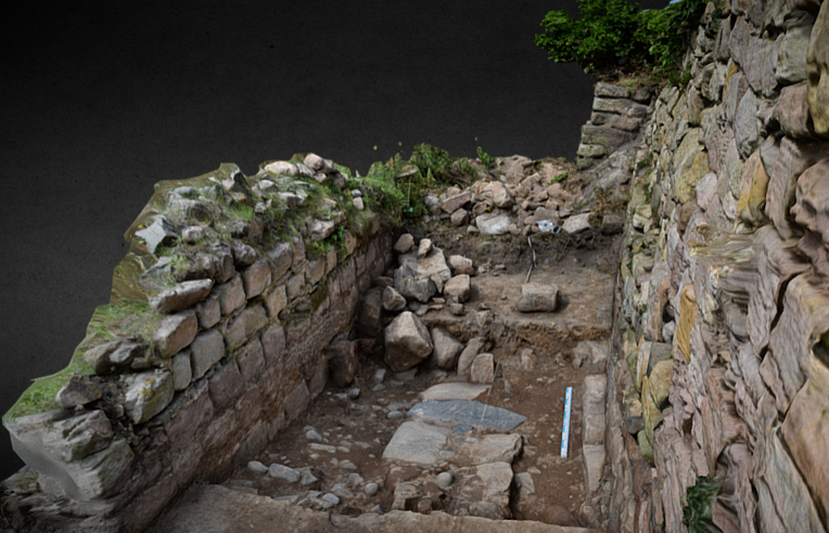
3D Model of Trench 5E with possible foundation wall

Trench 5E was a new trench opened in 2023, sited outside of the wall with the postern gate and the outworks. It was placed next to a short length of wall that we investigated in 2022 to see if it had once extended further. It has revealed a stone alignment that extends parallel to the two standing walls. Those of the outworks and the short wall length. So far only the upper level has been uncovered, so it is possible that it could be either a wall top or a foundation or the surface of a narrow path.


We think being able to share these 3D models, alongside the traditional interim report, really helps others who have not been to site to visualise the structures and our progress to date.

Please check back soon to take a look at the preliminary masonry report that will add further detail to the 3D models above.


Excavation Season 2024: Booking is open!

30th June – 26th July 2024 (4 weeks)

Join us this summer for our 2024 excavation season at the world famous Bamburgh Castle.

We will be continuing our excavation and survey on and around the outworks at St Oswald’s Gate; the latest chapter in our investigations of this fabulous multiphase site whose history spans at least 3000 years. The dig will run for four weeks from the end of June to late July 2024, starting Sunday 30th June.

You can find out more about our field school by visiting our Archaeology Field School 2024 page on our website.

If you are ready to book a place please head straight to our Booking Details page.

We also aim to offer two separate post-excavation focussed weeks this year as well. Keep an eye out for more details on what these will involve soon.

Excavation at the outworks beyond St Oswald’s Gate.

Where will we be working this season?

We have had three really good seasons on this site already and made some fascinating discoveries – such as the surviving stone arch into what must be the well-room at the base of the Tower of Elmund’s Well. This year we aim to finally find the base of the tower and the well itself. In addition we will begin to survey the mounds to the landward side of the outworks that may be a siege castle dating back to 1095 AD. It promises to be a very exciting season!

If you want to read up on the history of this area of the castle, how it relates to the other areas of excavation, and what we have discovered to date, take a look at our Bamburgh Castle: St Oswald’s Gate website page and look back on the blog entries here from previous seasons.

The Tower of Elmund’s Well under excavation

We welcome people from all ages and backgrounds

We are lucky to be able to welcome to the dig people of all ages and backgrounds, not just students of archaeology, and we feel that this makes for a friendly and welcoming team and a fun experience.

If anyone is interested but worries that mobility or other issues might be problematic then do get in touch with us via the Contact us page on the website and we will do as much as we can to accommodate you.

Director’s End of Season Excavation Round-up

The focus of our work over the last three seasons has been the investigation of the outworks beyond St Oswald’s Gate and in particular the Tower of Elmund’s Well and our ongoing search to find what remains of the well within it. You can read our previous seasons excavation to round-up to here to see where we started at the beginning of this year’s dig season.

Tower of Elmund’s Well

We have been surprised, delighted and even a bit astonished just how much of the tower survives even if this discovery has involved moving a lot of rubble! The stairs down into the tower, by the end of the season, had passed through the archway and into the tower room itself. This would suggest that although we have yet to reach the floor there is less and less space for many further steps before we will reach the far wall so we feel that the floor is probably no more than 1 metre deeper, and hopefully somewhat less.

This season, with the fence that surrounds the outworks moved back a little to allow for more space, we were able to start a trench outside of the turret to the seaward side to expose the outside of the wall face.

The tower wall before the seaward side was exposed.

This was to give us a proper understanding of the width of the wall, the top of which had been altered substantially it seemed when the tower was converted into a cottage. Here, less than a metre down, we found that the wall survives wider than it appears at the top, where some facing stones had been removed. As we excavate deeper (next season) it is hoped to identify buried ground surfaces, now covered by the windblown dunes, and perhaps even the ground surface contemporary with the tower’s construction.

One of the more interesting finds from within the backfill within the tower was a well constructed metal bucket. It is of course tempting to see this as associated with the well – perhaps the last well bucket that was in use! Of course there is every likelihood that it was just another item disposed of in the backfill, along with a car wheel and other household items, but we can still hope to identify some of the machinery needed to work the well abandoned at floor level.

Allen with the bucket!

Postern Gate and Wall

This season also saw further work on the external postern gate that leads out to the village. This involved continuing the excavation immediately behind it to uncover more of the structure. The intent for this was to uncover more of the wall to help interpret it, perhaps recover some datable finds, and if fortunate, see if we could find the level from which it was constructed. We had certainly not at all expected to discover what we actually found which was a gap in the wall that was deliberate. The gap was not there because the wall had been robbed away as it had deliberately constructed faces. The width and form of this strongly suggested a second narrow gate.

The gap in the postern wall that must be a second and perhaps earlier postern gate

The outside face that looks out to the village had been blocked by a single layer of masonry to close off the gap. It was also evident that it was quite high up (on the outside) as it bottomed onto a spur of the bedrock. This means the gate was at ground level on the inside but was a couple of metres above it on the outside. There is no trace of a stair up to it, so it seems likely that there would have been a wooden stair, which perhaps would have made it a little more defensible as it could be discarded in the face of an enemy.

It does not seem to make sense that there would be two posterns next to each other so its tempting to see one as replacing the other. As the current path leads to the one that is still, in its way in use, its natural to assume that this is the later one, but this may be false as we simply cannot be sure the positions of the path in early times.

Trench 5e the new feature that is something of a flashback to T3

This season we opened a new trench on the outside of the wall with the postern gate (now two gates). The new trench was next to the short length of wall that we investigated last season to see if it had once extended further. Rather disappointingly we found that it confusingly just ended rather abruptly with no trace of foundations extending further, or even of a robber cut where once could have been removed. The new trench was opened between that wall and the postern wall and thankfully has proved to be much more interesting.

It has revealed a stone alignment that extends parallel to the two standing walls. So far only the upper level has been uncovered, so it is possible that it could be a wall top (or foundation) or just a surface like a path. It is made of dolerite and sandstone and in this, along with its width and general form, it is very reminiscent of some of the early medieval features the we saw within Trench 3 (within the castle). Here these features had been interpreted as stone foundations for timber walls. It is then very intriguing to wonder if we are seeing the same kind of feature here in the outworks, and even more interesting should the feature prove to be of similar date. One of the questions we asked ourselves at the beginning of the work on the outworks was – could we find any evidence for structures and arrangements from the early medieval period? After all we know the entrance was in use from this time and likely centuries earlier, so there must have been access routes and perhaps structures associated with this use and also control of the small port.

The new linear structure between the two standing walls that could perhaps be a wall base, with a possible ground surface to the left in the photo.

Geophysics

We were very fortunate to have a geophysical team from Southampton University with us for a few days in our final week. This was a part of the work on understanding and recording the outworks at St Oswald’s Gate that has been generously funded by the Castle Studies Trust. We will report in much greater detail on this and on the 3D recording and building survey in future blogs, as the results are worked through. As of now we have seen just enough information from the geophysics undertaken on the green in front of the castle to know there will be lots to discuss, including what at first sight may be some early features on the far side of the green. Not bad when we really only hoped to find trace of a ditch extending towards Oswald’s Gate and the port area.

Booking for the Post-Excavation Taster Week is now open

Dates: 10th – 14th September 2023


Bookings are OPEN for a 1 week post-excavation taster.


Two people sorting finds from the environmental flotation system
Participant recording artefacts

What is post-excavation?

Archaeology is not all about digging. In order to turn the data gathered through excavations or surveys (for example) into information that can be used to interpret a site and/or plan further investigations, archaeologists must process this data during the ‘post-ex’ phase.

This includes recording the artefacts recovered, processing the environmental samples taken, digitising the drawings and survey information, for example. This work generates a physical and digital archive, which connects all the pieces of information together. It takes far longer (in most cases) than the actual field work and often takes place in the lab or at the desk.

Post-Ex at the Bamburgh Research Project

Here at the BRP we have generated a lot of post-excavation work in the last 20 years. We undertake much of the initial post-ex on site, where we wash and process the small and bulk finds, we process our environmental samples and we catalogue much of the records and photographs we take. However, there is still much work that is undertaken during the off-season by our staff and more that is sent away for specialist analysis. We thought this year we might bring some of this ‘behind the scenes’ work back to the Castle and share it with a small cohort of interested individuals.


What is the Post-Excavation Taster Week?

We offer quality training in archaeology with an emphasis on practical hands-on experience. The post-excavation taster week will use the BRP’s extensive archive, which consists of material from the prehistoric to the medieval periods, as the basis for an introduction to the different post-excavation techniques and research methodologies employed by the project.

We are still planning the daily schedule but the week will include:

Please Note: we are also in the process of organising a visits by a Specialist but these are yet to be confirmed.


Who is it for?

Our training is open to people of all skill-levels and abilities, with particular interests accommodated where possible. We particularly wish to offer a fun and educational experience to beginners and non professionals.

Please get in touch with us if you have any questions about access, facilities, etc.

BRP is open to anyone aged 18 and over. 

Who will be teaching me?

Professional field archaeologists and post-excavation specialists.

How much does it cost?

The post-excavation taster week costs £300 pp and covers 5 days of training in a small group of between 6-8 people. This covers the cost of the tuition, tours and the trip to Lindisfarne.


How do I book a place?

Please visit the BRP’s website and take a look at the Post-Ex Taster Week page. At the end of the page is the details on how to book and pay for your place.

PLEASE NOTE: the week will only run if the BRP receive enough bookings to make the week viable (more info on website).

Any questions? Email: graemeyoung@bamburghresearchproject.co.uk

Funding Success for the Bamburgh Research Project with the Castle Studies Trust

The Bamburgh Research Project (BRP) are pleased to announce that we have been successful in securing £9306 from the Castle Studies Trust (CST).
Over the next 12 months the BRP will be utilising the funding to further explore Bamburgh Castle’s medieval outworks, particularly the area outside St Oswald’s Gate where our current excavation is underway as part of our annual field school. Our project is titled ‘Contextualising Bamburgh Castle: wells, towers, mounds and more!’

St Oswald’s Gate and the Medieval Outworks

St Oswald’s Gate and the outworks beyond lie in the area of the original entrance to the castle. It is very likely that the siege castle (named Mal Voisin in the Anglo-Saxon Chronicle) was built close to this gate in AD 1095. When the main access was re-sited, the entrance here remained as an important postern. Perhaps serving a small adjacent harbour immediately to the north of the site. This area now forms the BRP’s main investigative focus. The outworks consist of strong walls enclosing a trapezoidal area with the Tower of Elmund’s Well. With a more recent wall and postern to the west.

The outworks at St Oswald’s Gate are a rare case at Bamburgh as they have not been subject to extensive rebuilding in the post medieval period. Other than the reconstruction of the tower as a cottage, the outworks represent an astonishing window into mostly unaltered medieval fabric still standing at Bamburgh.

Foreground shows the area currently under excavation by the BRP with St Oswald’s Gate visible at the top of the steps and West Ward of Bamburgh Castle present in the background.

Work to Date

Recent investigation by the BRP has revealed that a substantial structure still survives below ground. This is in the form of an L-shaped corridor and steps down into the room that is thought to be the tower basement that contained the well. The presence of two splayed narrow windows appears to further indicate that this is part of the medieval Elmund’s Tower. The 2023 excavation season aims to reveal the full extent of the tower and identify any remains of the well depicted on the 19th century survey. You can find out more about our ongoing excavations in this area by taking a look at earlier blog posts: Investigations beyond St Oswald’s Gate: End of Season Overview.

What will the CST Funding be used for?

There are two primary aims for the CST funding. The first is to contextualise our recent excavations at Elmund’s Tower through geophysical survey (GPR and Magnetometry) and undertake a preliminary masonry survey of the castle’s associated extant outworks.

The geophysical survey will provide context to the area immediately outside of the outworks and identify if the castle ditch (seen as a rock cut feature at the Great Gate) extends all the way along the front of the castle. As part of the masonry survey the project will be using photogrammetry to create a 3D model of the standing outworks and internal structures of Elmund’s Tower. The survey will be undertaken in conjunction with a metric survey of the structures outlines so that a photo-real, stone by stone, 3D photo model can be used as a management tool for future plans, including consolidation work.

The investigation of the area will be used to aid in making management decisions to ensure the preservation of the outworks. More broadly, the proposed investigations will assist the interpretation of the extensive, but more complex and disturbed stratigraphical sequences recovered elsewhere in the castle, principally the West Ward.

We will also be using the photogrammetry and geophysical surveys as an opportunity to upskill BRP staff and provide add-on benefits to students during our annual field school (July 2023).

The second focus for the funding will be on disseminating our discoveries to the wider public. Bamburgh Castle is in the process of re-focussing the story it tells the public, giving greater focus to its medieval and early medieval history through a new website, signage throughout the grounds and new displays within the castle itself. However, the medieval outworks are inaccessible to the public and there is currently no opportunity to highlight the ongoing research into this area of the castle and how the site was shaped by the surrounding topography. The funding will allow us to create and install signage for visitors with a QR code for the 3D model, granting online access to Elmund’s Tower and the wider outworks. This information will also be replicated and enhanced with the creation of a new webpage on the Bamburgh Castle website. Alongside these permanent additions we will continue to share our work through our blog and social media.

Listen to two of our Directors discuss the project with the CST

Project Directors, Jo Kirton and Graeme Young, recently spoke to the CST about the project, which you can listen to here:

Make sure you follow our blog and social media accounts to see how the project progresses over the summer. We cannot wait to share what we discover!

Two places are now available to book in Week Three

Booking has filled up very fast this year but two places have now become available! These are both for Week Three (16th July to 22nd July) and as this is the week we will also be doing geophgysics as well as completing the excavation, it should be a really good one to be on.

Booking information, the booking form and email to ask any questions is available through this link

We look forward to seeing you in July

Archaeology of the Last Kingdom online talk

The Bamburgh Research Project will be taking part in an online talk to discuss the archaeology of the Last Kingdom.

Coinciding with the release of The Last Kingdom: Seven Kings Must Die, this event is designed to appeal to fans of the series, highlighting the ‘real’ history and archaeology behind the show.

The event is free for anyone to attend, and a recording will be made available on YouTube at a later date.

Booking and informaion for the online event can be found here: digventures.com/product/the-archaeology-of-the-last-kingdom

Introducing our Newest Director….

We are really pleased to introduce our newest Director, Constance Durgeat!!!

Many of you will know Constance as she has been with the project since 2010 and many more will recognise her from our social media and blogs. Constance has been an amazing team member and over the past few years she has managed our excavations at the castle and looked after everyone off site.

Constance first joined the Bamburgh Research Project as an undergrad student in Art History and Archaeology from the Sorbonne University in Paris. After a Masters’ in Urban Archaeology, she moved to York to complete a Masters on Bamburgh’s metalworking area in Trench 3. She was then made supervisor of Trench One and carried out more roles over the years.

For Constance, coming from France where community archaeology does not really exist, it was (and still is) very exciting to get to teach anyone, no matter their level or education! Thanks to this interest, she has worked for seven years with the University of York, teaching first-year students fieldwork techniques and environmental processing. She has worked with multiple commercial companies, digging a variety of sites across England to keep her skills up to date. She now works as a Senior Archaeology Consultant with Rocket Heritage and Archaeology. Her main interests are Anglo-Saxon and medieval archaeology and buildings archaeology.…and travelling around the world when she has time!