Director’s End of Season Excavation Round-up

The focus of our work over the last three seasons has been the investigation of the outworks beyond St Oswald’s Gate and in particular the Tower of Elmund’s Well and our ongoing search to find what remains of the well within it. You can read our previous seasons excavation to round-up to here to see where we started at the beginning of this year’s dig season.

Tower of Elmund’s Well

We have been surprised, delighted and even a bit astonished just how much of the tower survives even if this discovery has involved moving a lot of rubble! The stairs down into the tower, by the end of the season, had passed through the archway and into the tower room itself. This would suggest that although we have yet to reach the floor there is less and less space for many further steps before we will reach the far wall so we feel that the floor is probably no more than 1 metre deeper, and hopefully somewhat less.

This season, with the fence that surrounds the outworks moved back a little to allow for more space, we were able to start a trench outside of the turret to the seaward side to expose the outside of the wall face.

The tower wall before the seaward side was exposed.

This was to give us a proper understanding of the width of the wall, the top of which had been altered substantially it seemed when the tower was converted into a cottage. Here, less than a metre down, we found that the wall survives wider than it appears at the top, where some facing stones had been removed. As we excavate deeper (next season) it is hoped to identify buried ground surfaces, now covered by the windblown dunes, and perhaps even the ground surface contemporary with the tower’s construction.

One of the more interesting finds from within the backfill within the tower was a well constructed metal bucket. It is of course tempting to see this as associated with the well – perhaps the last well bucket that was in use! Of course there is every likelihood that it was just another item disposed of in the backfill, along with a car wheel and other household items, but we can still hope to identify some of the machinery needed to work the well abandoned at floor level.

Allen with the bucket!

Postern Gate and Wall

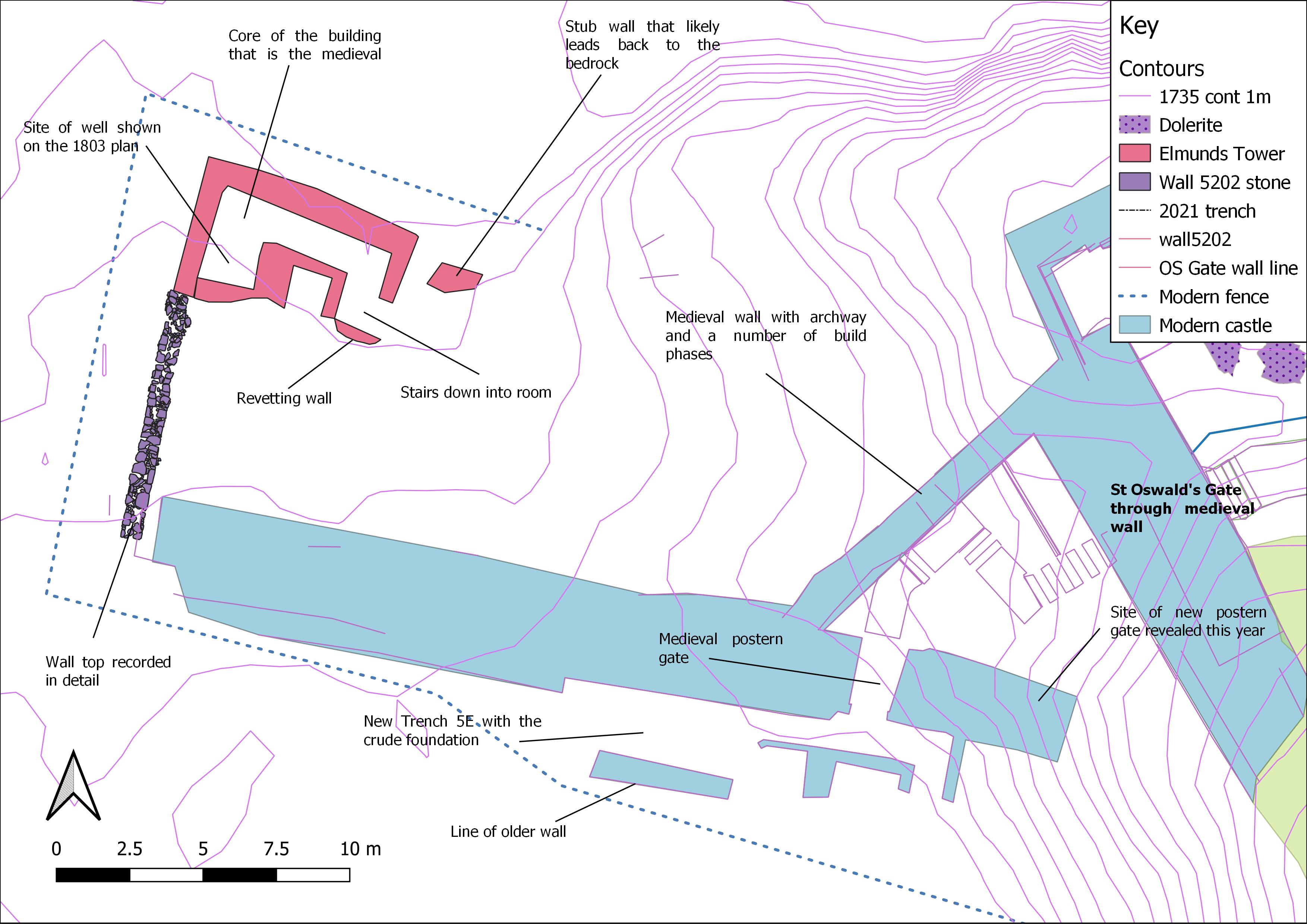
This season also saw further work on the external postern gate that leads out to the village. This involved continuing the excavation immediately behind it to uncover more of the structure. The intent for this was to uncover more of the wall to help interpret it, perhaps recover some datable finds, and if fortunate, see if we could find the level from which it was constructed. We had certainly not at all expected to discover what we actually found which was a gap in the wall that was deliberate. The gap was not there because the wall had been robbed away as it had deliberately constructed faces. The width and form of this strongly suggested a second narrow gate.

The gap in the postern wall that must be a second and perhaps earlier postern gate

The outside face that looks out to the village had been blocked by a single layer of masonry to close off the gap. It was also evident that it was quite high up (on the outside) as it bottomed onto a spur of the bedrock. This means the gate was at ground level on the inside but was a couple of metres above it on the outside. There is no trace of a stair up to it, so it seems likely that there would have been a wooden stair, which perhaps would have made it a little more defensible as it could be discarded in the face of an enemy.

It does not seem to make sense that there would be two posterns next to each other so its tempting to see one as replacing the other. As the current path leads to the one that is still, in its way in use, its natural to assume that this is the later one, but this may be false as we simply cannot be sure the positions of the path in early times.

Trench 5e the new feature that is something of a flashback to T3

This season we opened a new trench on the outside of the wall with the postern gate (now two gates). The new trench was next to the short length of wall that we investigated last season to see if it had once extended further. Rather disappointingly we found that it confusingly just ended rather abruptly with no trace of foundations extending further, or even of a robber cut where once could have been removed. The new trench was opened between that wall and the postern wall and thankfully has proved to be much more interesting.

It has revealed a stone alignment that extends parallel to the two standing walls. So far only the upper level has been uncovered, so it is possible that it could be a wall top (or foundation) or just a surface like a path. It is made of dolerite and sandstone and in this, along with its width and general form, it is very reminiscent of some of the early medieval features the we saw within Trench 3 (within the castle). Here these features had been interpreted as stone foundations for timber walls. It is then very intriguing to wonder if we are seeing the same kind of feature here in the outworks, and even more interesting should the feature prove to be of similar date. One of the questions we asked ourselves at the beginning of the work on the outworks was – could we find any evidence for structures and arrangements from the early medieval period? After all we know the entrance was in use from this time and likely centuries earlier, so there must have been access routes and perhaps structures associated with this use and also control of the small port.

The new linear structure between the two standing walls that could perhaps be a wall base, with a possible ground surface to the left in the photo.

Geophysics

We were very fortunate to have a geophysical team from Southampton University with us for a few days in our final week. This was a part of the work on understanding and recording the outworks at St Oswald’s Gate that has been generously funded by the Castle Studies Trust. We will report in much greater detail on this and on the 3D recording and building survey in future blogs, as the results are worked through. As of now we have seen just enough information from the geophysics undertaken on the green in front of the castle to know there will be lots to discuss, including what at first sight may be some early features on the far side of the green. Not bad when we really only hoped to find trace of a ditch extending towards Oswald’s Gate and the port area.

Week 3 Round-up (finally)

The last week of the season was a whirlwind! We had multiple specialists on site as well as representatives from various heritage and environmental institutional bodies, and we had to make sure everything was recorded and packed away for the off-season.

In finds, Margot’s team repacked artefacts taken out for student and visiting scholar research, ensuring they were still in superb condition (monitoring humidity strips and changing silica gel specifically) and not showing any signs of degradation. The probable gaming piece below left was used as an example for pitching a new exhibit of currently-off-display finds to the castle team. The finds bags in the middle were a few examples of melon beads selected from a large quantity we pulled for our student Helena to examine for her independent glass bead research. On the right, you can see our massive collection of single stycas…this doesn’t even include the hoard! A coin expert joined us one afternoon, so we moved the solo stycas temporarily into a context tray so they could flip through them easily in context order.

The students working with environmental sorted through a number of backlogged samples that had been floated, inventoried the storage areas, and moved all recent sorted samples into new boxes. We’ve created a new box system for environmental material, as it is usually one of the first categories of materials to get moved around by castle staff in their regular custodial and care-taking duties. New filing systems don’t sound super interesting when we put it like that, but it’s vital to meticulously manage and track our environmental archive. It also means new spreadsheets are afoot! We pulled all the newly-dried flots that fit the parameters of Alice Wolff’s archaeobotanical PhD studies, which we discussed here and here. And lastly cleaned the flot tank out one final time!

Out on the green at the base of the castle, our colleagues Kris Strutt and Dom Barker from Southampton continued to teach our students to gather data via resistivity, magnetometry, and GPR. Kris also popped into the Inner Ward to see if he could record any usable data in the highly-disturbed area at the top of the mount, while Dom explored one of the fields adjacent to our medieval harbour. We have preliminary readouts of the surveys, but our analysis is not quite complete. When Kris and Dom finish their current assignment (and have a few days to rest from all that walking), we will reconnect with them, better articulate what we were seeing, and ideally identify the various anomalies.

We also welcomed two guest specialists to our open trenches! Peter Ryder, a medieval buildings expert, spent the day poking and pondering about the multiple phases of masonry we have in the outworks. We hope to have an update on his findings in the near future. Tony Liddell, a photogrammetry expert, joined us to take high-resolution, overlapping photos of our trenches to create 3D models. Both of these consultations were made possible due to our funding support from Castle Studies Trust.

Finally in the trenches, we extended 5D, 5E, and 5F before recording them and closing them. Our blocked entranceway (5D) was extended towards the Victorian stairs to what we had been calling the postern gate. We uncovered rubble under the foliage and then a gentle slope of earth. 5E, between the two medieval walls, revealed more pavement of flagstones and cobbles. Trench 5F, for some reason referred to as “Betty” by the students, gave us access to more of the façade of the tower but we only brought it down to the top of the windblown sand layer first seen in last week’s round-up.

We also removed some more rubble from the well room, which has still not been bottomed-out. The paparazzi did catch this rare photo of Claire Watson-Armstrong, and we were so excited to have her on site! She has been a vocal supporter of our work, and it meant a lot for us all to see her having a blast on the hunt for the medieval well.

A woman in a white hard hat smiles gleefully in a medieval stone chamber that extends far above her. She holds a small artefact up for the camera. A young man kneels beside her removing rubble.
Claire Watson-Armstrong down in the well room!

Thank you so much for following along this season! We appreciate your patience getting this final update posted, as we all went our separate ways Saturday morning and immediately back to our day jobs on Monday. We’ve gotten a chance to breathe and organise our thoughts, so expect more content over the next few weeks: Graeme’s season round-up, our masonry theories, 3D models, and our geophys interpretation. Finally, thanks again to Castle Studies Trust who supported us in our endeavours this season. You can read all about the work we were able to undertake so far from their generous grant at this link, and updates on on our results will also be accessible from there in addition to the main blog page.

And don’t forget about our post-ex week the 10th through 14th of September! We would love to see new and old faces there as we focus on finds processing, identification, and analysis!

Geophys: Days 2 and 3

We are almost finished with the electrical resistivity survey of the green around the cricket pitch, and we have also begun magnetometry! Talking through some of the preliminary results has revealed that even though this is a “hard science” collection of empirical data, it goes hand-in-hand with archival research, which we will talk about briefly at the end.

Smiling man in a blue hoodie holds an H-shaped white rig with the outer wall of a castle and some vegetation-covered mounds behind him in the middle distance and background.

The process for walking the grid system for magnetometry is much the same as the process we described earlier for resistivity with respect to our grid system, but we also have to account for the different spacing between the sensors. We are making each traverse (each straight line across the grid square) a half metre, and the instrument will take a measurement every 0.25m. We will receive four readings in each square and survey a swathe of 2m for every two passes. This survey can therefore be a bit quicker than the previous method we used.

The data is not fully processed yet, but we do have some intriguing bits that are showing up. Some of these are reasonably-confidently identified, but others are still a mystery. Running along the base of the rock, there seem to be utilities lines that the spotlights on the green are tapped into. (We have small, square gaps in our data because of the presence of those lights since they are caged.) There are also a number of utilities or services trenches by the edge of the pitch near the junction where you can turn to get onto the grass or continue up the paved ramp to the castle car park. The presence of the row of lights suggests that the cables from the northwest meet up with the hub in the southeast.

In addition to this modern material, we can see evidence of older roads or trackways. Just how old they are is still to be determined, but there are at least two in use in the 19th century, because our geophys team was able to cross-reference with their data with Ordnance Survey maps. The map below is from the 1860 survey’s first edition, and you can see the two paths across the green in the magnetometry data that is still being “cleaned up.” We will be publishing the full results in the fall hopefully, but for now, it’s probably better to show you the OS map so when the data is fully processed you can refer back to this post for the archival images that best exemplify the features we are picking out from the raw data. One path crosses the green where the cricket pitch now stands and might be heading towards the lowest part of the cleft that allowed access to the area of the well tower (which continues up the mount to Saint Oswald’s Gate). The trackway might be very old indeed, since the gate was the original entrance to the castle pre-Conquest. The other path heads directly for the Miller’s Nick. The Miller’s Nick is a narrow gap through the castle walls that gave the local community access to the West Ward’s windmill to grind their grain. Sometime after the sudden death of Dorothy Forster in 1715, her husband Lord Crewe devoted a portion of his resources to the local community at Bamburgh. If you’ve been to the West Ward, you would see a small staircase coming up right beside where Trench 3 was, crossing through the wall where Brian Hope-Taylor’s little offices are located.

Black and white ordnance survey map of Bamburgh Castle showing the major walls of the compound, slopes of green spaces, and contemporary footpaths. Additionally, plots on the edge of the village are numbered.
1860 Ordnance Survey Map, image from an old BRP blog post, but normally full file must be purchased from OS website.

There are some digitised images on Historic England’s archival site, and one also confirms that the Miller’s Nick path continues in use during the second half of the 19th century. Below is a view out from the castle towards the village, but there are still fields in use at this time; the crop field you can see is at the bend in the road and surrounded by a wall. In the OS map, the area labelled “45” is the field you’re seeing below. See the diagonal path at the very bottom of the photograph below? That seems to be the same path shown on the OS map.

Image from Historic England’s curated collection of early photographs, but their native embed code is not updated for this image. Access the record here.

The 1898 OS map held in the National Library of Scotland’s archives does not show the Miller’s Nick path anymore, nor the field plot that once filled the far side of the green. The abbreviation FP seems to be denoting extant footpaths. The advent of accurate cartography of Britain by the commissioning of the OS combined with the increased accessibility of photographic equipment is showing us the transformation of the green through visual media. The digitisation of these records makes historical landscape research much easier than the days of poring over giant maps in a reading room. Both approaches are however only successful due to the tireless work of archivists, for whom we are grateful.

Another black and white ordnance survey map of Bamburgh Castle showing the major structures of the compound, slopes of green spaces, and no visible footpaths. Additionally, plots on the edge of the village are numbered.
National Library of Scotland, “Northumberland (Old Series) XVII.1” published in 1898.

So we’ve got some identifications, but there’s still a few other features we haven’t nailed down yet. Extending out from the rock face are two wide bands that cross each other just to the south of the cricket wicket (which itself only appears on maps around the 1920s). They are linear features that are 3 or 4 metres wide extending from the base of the mount beneath the clock tower. We compared this to the same grid squares in the resistivity data and found that the wide features are not particularly deep down in the earth. Beside that wobbly X-shaped area, multiple linear features 30 metres long also start at the base of the mount, continuing onto the green. They terminate abruptly as if they were cut away during later landscaping. The green was sheep pasture at times, but we don’t know of any recent (last two centuries) programmes of works that may have gouged the earth near the base and could have destroyed those linear features.

Finally, we have rectilinear features on the edges of the green near the modern road where the field with the wall in the photograph stood. Structures in the same location are not recorded on the OS maps, so they are likely earlier than the 19th century. The next step might be to check paintings of the castle that feature that edge of the village. We also received some photos from locals that showed the outlines of structures in the grass of the green during exceptionally dry periods, as grass and crops can reveal underlying archaeology when the soil is parched.

One of the things that was pleasantly surprising about having the geophys team here was that we realised that this survey opportunity wasn’t just about numbers and maths and computer processing of huge datasets. The few head-scratching preliminary results of this survey also prompted us to go back into library archives and curated image collections for more media of the castle and the village. We revisited maps, photos, and art we had seen over the years, but also discovered newly-accessible images in major national repositories AND personal photographs from local residents. Archaeology is truly an interdisciplinary science that relies on the material culture, the clues in the ground, and the historical record when possible. We look forward to sharing our interpretations of this mag data with you all as soon as possible, so stay tuned!

This blog is brought to you as part of our 2023 grant-funded activities through the generosity of the Castle Studies Trust.

Week 2 Round-Up and Return of the YACs

Week 2 was exceptionally busy! We made progress in some new areas, as well as getting an unexpected revelation about our well room. Finds and environmental processing continued, and we welcomed our geophys specialists to begin surveying the cricket pitch at the base of the castle. Finally, we also hosted the winners of the YAC Dig It! competition to spend a day at Bamburgh excavating and learning about the different jobs archaeologists do on site.

We opened a trench (5F) on the seaward side of the tower structure (just on the other side of the well room). So far, we have exposed a bit of what might be the outer face of the wall (those blocks sticking further out into the trench).

Rectangular hole in the ground with sand at the bottom; the front of a roughly-hewn wall.

In addition, we realized that the well room goes down at least another metre using the exceptionally scientific process of probing some of the spaces in the new rubble layer we reached. When we say probing, we really mean just using a long stick to poke down to get an idea of any cavities or areas of particular soil compaction.

We began dismantling the fill of the blocked entranceway by Saint Oswald’s Gate in Trench 5D. You can see the abrupt, but even, face of worked stone that would have been the door jambs. There is also a large stone that is cut and worn as if it held a large hinge of a gate or door.

Finally, on Friday, we revealed a cobbled or flagstone surface in Trench 5E. It sits lower than the top course of foundation stones we revealed at the base of the higher extant wall (below right). Could this have been a pavement from before that phase of masonry?

This week multiple objects came out of environmental processing, including this copper alloy fitting and a bit of iron nail both from soil samples near the metalworking building in old Trench 3. The nail was particularly interesting as the corrosion seems to have preserved wood grain in the rust; this happens especially with iron because the corrosion product absorbs nearby materials into the rust, and archaeologists sometimes find iron with bits of bone, pottery, and glass protruding from the corrosion. This nail was from a posthole, so it may have been used to secure parts of the metalworking building’s timber structure.

In finds, we’ve been washing and sorting material from the well room, including parts of a hand-cranked automobile, which is a bit hard to date because they were being produced up until the 1960s, but the tyre seems WWI-era! What’s going on here? See below left for the tyre, petrol tank, and crank. Below right is what looks like the pieces of a sink. Many broken bits of bottles and pottery have been brought up for processing, and some of it is identifiable to a specific company by maker’s marks and glazed patterns respectively. Since these bits are coming from the same context, we can pull all the ceramics and practice pot-mending with them.

Our friends from the University of Southampton arrived at the end of the week to help us survey the cricket pitch for associated defensive structures like ditches or moats from the medieval period. You can read more about our first day surveying here.

Finally, we welcomed Abbie, Myles, and Willow from the Young Archaeologist’s Club. They won a day on site with us, so we took them around the new trenches and the West Ward, showed them some of the finds from our teaching collection as well as the stuff coming out now, and then let them try a hand at flotation!

Geophys: Day 1

Our guest specialists from University of Southampton Kris Strutt and Dom Barker joined us on site yesterday to check some of their equipment before taking on small groups of students today. This morning, they taught the students how to properly set up a grid system for survey, and then spent the rest of the day having students take electrical resistivity measurements on the cricket pitch at the base of Bamburgh Castle.

Six people stand on green grass with a castle on a rocky outcrop in the background. The person in the centre of the image is holding a staff with a GPS system on it.

Setting Up the Grid

Before you can start surveying with geophysical techniques, you need an accurate grid system to ensure you are collecting data points that can be georeferenced to known locations, such as the Ordnance Survey maps produced for Britain. We used grid systems within our old trenches in the West Ward, which worked like a Cartesian plane (the x- and y-axis you used in maths in school). Every square metre of the trench could be associated with an Easting (x-coordinate, how east or west something is) and a Northing (y-coordinate, how north or south something is). (Weirdly, in American archaeology, you order them the other way around: Northing, then Easting.) Sorry, that’s a lot of parentheses. Anyway, in the old days we could use these coordinates to locate objects found in the sieve, because you could check the coordinates for the metre square you were digging in along with the context to narrow down the location; normally, small finds in the trench are replaced by a tag that we can measure with our EDM or dumpy level for elevation. Now we are applying a similar grid system to the cricket pitch!

Four people gather standing on the grass around a man with a GPS staff to look at the screen.

We were able to use a portable GPS staff to place a peg and bamboo stake (nearly) every 30 metres running from North-South across our survey area. We were basically on a diagonal from the outworks to the village, starting at 180 East/120 North. We moved south 30 metres, siting our next grid peg at 180 East/90 North. See how the Northing went down by 30? We moved south again, bringing us to 180 East, 60 North for the next peg. Once we put in as many grid pegs as we could, we moved east 30 metres and put in another North-South line of pegs that were parallel to our first line. This could be done with a compass with a sight along it, but the GPS staff allowed us to quickly find each coordinate. The screen would tell you what your coordinates were very precisely, so precisely that not holding the staff perfectly upright (with a little leveling bubble like the dumpy level stadia rod and EDM prism staff) could skew you by several centimetres at least. Being off by a few centimetres is not the end of the world, but ideally you want to only be off by 5cm at the maximum, and 1cm or less was preferable. We couldn’t get right up to the base of the mount in some areas due to vegetation, so we put in points 15m which were halfway between the 30m intervals so that we could still record points with our tech after. Normally we would be taking data points in each 30m by 30m square, but sometimes we couldn’t make a full square and had to use a partial square. When we began the resistivity survey, we made sure the students got practice on the full squares before setting them loose on the partial squares. All of this data could be downloaded at the end of the day via USB, and then we can import it into GIS (geographic information systems) software.

A closeup of the GPS system computer screen with a keypad below it. You can see the reflection of the transmitter in the screen.

The GPS system also had a voice that confirms your choices when you press buttons on the keypad, but it’s a generic American woman’s voice. Our team had a grand time suggesting sillier and sillier voices to include in the software so it would work like your automobile GPS and have different voices to set. The top four silly voices for the fancy GPS staff were: Brian Blessed (“To the LeeeeeeeEEEEeeEEEEEEeeeFT” but like this), Homer Simpson, Joanna Lumley as Patsy from “Absolutely Fabulous,” and Samuel L. Jackson (providing a stream of expletives, not linking that here).

A man in a navy blue sweater and grey bucket hat unwinds a roll of white washing line. Behind him a man in a blue hoodie with a grey baseball cap untangles another white washing line.

Once we got that large scale grid system in place, we laid out two surveyor tapes North-South at two adjacent lines of grid pegs. We had long stretches of washing line (without a metal core so it wouldn’t skew the signal) that had metre intervals marked, as well as a marker at 15m. We placed these East-West from one surveyor’s tape to the other so that they were perpendicular to our parallel pair.

Finally, we were ready to break out the electrical resistivity equipment.

Resistivity Process

You can learn more about the technology here, but we wanted to add some specifics from our survey. This methodology is all about closing a circuit, allowing electrical current to flow through the earth. We are measuring potential of a circuit (work done to move the current, voltage) and the resistance of the circuit (how easy it is to move the current). We were using a twin probe array, so we had a mobile pair and a remote pair connected to the ground a bit away from our grid square but all connected with cable. We are expecting high resistance, so our survey is done at a resolution (think of camera pixels) of 1 Ohm. Our survey is done at a resolution (think of camera pixels) of 1 Ohm which is the unit of resistance. 1 Ohm is 1 Volt (unit of electrical potential) per 1 Ampere (unit of electrical current).

A rectangle of metal pipe lies flat on the grass. The lower edge is a thicker bar with wires along it and two spiked metal probes protruding from the bottom. Two bamboo stakes lie at the bottom of the image.

You place the probe in the centre of the metre by metre square you’ve created with your various surveyor’s tapes and lines and wait for the machine to beep. The beep tells you a measurement has been taken; at the end of the line, it makes a longer beep to confirm you have 30 squares-worth. If you hear that long beep too soon, you’ve taken too many points thus far, and if you don’t hear it, you’ve not gone far enough, so either way you know if you goofed!

It doesn’t really matter which way you are facing when you begin your walk, but our experts suggested we all face north and head left to right (east to west) for the first pass. Then we would turn around at the end of the 30m and move south to the next row, heading back right to left (west to east). This made things easier to see in our mind, and it gave us a way to keep track of our path so we don’t goof up! If all your odd-numbered lines are going right, then all your even-numbered lines would be going left. This won’t mess up your data, as the equipment just records a string of numbers. Unfortunately, this means your grid really has to be accurate; if you make an error taking a measurement, you need to erase a whole line or the entire dataset instead of being able to remove a single incorrect reading after the survey is complete. Having multiple methods to keep you on track and test whether your process is correct is actually very helpful! Wouldn’t you rather know that you goofed at the end of a 30m walk than after you’ve surveyed a whole field?

A bearded man in a grey sweater, grey hat, and blue jeans swings the rig to the right as he walks along a surveyor's tape.

We had a blast out on the cricket pitch today, and look forward to sharing some data with you once it’s all processed and interpreted at the end of the summer. Stay tuned because we have also just received permission to survey some of the fields adjacent to the early medieval harbour!

This blog was brought to you as part of our 2023 grant-funded activities through the generosity of the Castle Studies Trust.

Way Back Wednesday: Weaving Combs

In Paula Constantine’s talk yesterday, we spent some time learning about multiple types of looms and how the evidence of them archaeology is usually limited to the associated tools. There is also evidence in the Old English literature corpus, sometimes where you might not expect.

When you are weaving, regardless of the different types of loom available during the medieval period, you have a vertical threads called “warp” that are tensioned equally (often using loom weights). The threads you are pulling through horizontally are called the “weft.”  The tension keeps the warp taut, but the weft doesn’t have the aid of gravity to keep everything even. Weavers have developed different types of tools to push down the weft. There are beaters that look like blunt swords and bone or antler combs that look like hair combs with longer handles or bulky forks. We’ve got several of these weaving combs in our archive. The earliest one we have in our care wasn’t excavated by our team, or even Brian Hope-Taylor, but rather the locals nosing around the site in 1896. Notice the ring-dot motif we find on all sorts of material from the Roman period through the medieval. Remember our dice? BHT helpfully (sarcasm) glued it to some cardstock, and it eventually joined our archive when our team collected his materials from RCAHMS.

Grey bone fork-shaped comb on paper with handwritten identification.

Other weaving combs have been dated to as early as the Bronze Age, but the online digitised examples at the British Museum date from the Iron Age. Here are two lovely examples. They are most often categorised as “comb beaters” if you’d like to search for others. Whalebone weaving combs have been found in Orkney from this time period as well. Here is an interesting paper on Iron Age weaving combs in particular. They are used throughout the medieval period as well, and even today you can purchase fancy handmade versions for your own weaving work.

Medieval Textiles at Bamburgh

This evening, long-time friend of the project and medieval textiles expert Paula Constantine delivered her eagerly-anticipated lecture on the evidence for textiles at Bamburgh. She brought handmade, period-accurate replicas of fabric and clothing she has constructed over the years, in addition to tools associated with textile production. Because textiles survive so rarely in sites in general, but particularly here except in bogs and…ahem…wells, Paula explained that we need to look for secondary evidence of the craft. The one survival of textile we have at Bamburgh? The centimetre square of textile preserved IN the corrosion of the styca hoard. Since this is elusive evidence preserved by chance and chemistry in equal measure, we are reminded that lack of evidence is not equal to the wholesale absence of textiles and textile industry. The West Ward was the main locale for artisans at Bamburgh to ply their trade; textile production would have almost certainly taken place there, but as well among the high-status ladies of the royal household at the top of the mount. We must look to the spindle whorls for spinning thread, loom weights creating the tension in the rig to make woven fabrics, bone combs for arranging and tightening the woven threads. The loom itself? Wooden, and simply gone from the record. Stone and ceramic whorls and weights survive en masse, however. And we do lovely bone loom combs, even stretching back to Brian Hope-Taylor’s excavation (stay tuned for tomorrow’s Way Back Wednesday to see that).

A woman in a dark green plaid shirt stands between a table covered in yarn, fabric, and bone tools and a large computer screen.

We saw combs made of nails arranged in a row that could be used for plant fibre preparation as well as wool production. At Bamburgh, we also have a row of nails in a similar arrangement in the archive.

A row of nails sticks out of a wooden handle lying in a basket filled with raw textile fibres.

In addition, our archive and teaching collection contains numerous bone pins, possibly used for textile production but perhaps more likely for securing clothing. Here is a selection Paula has curated to show the variety of styles, from simple to more complex.

A blue strip of fabric is pierced with decorated animal bone pins with different carved heads. Bone combs and spindles are in the top right corner.

Here is one of several styles of leather shoe! (Just as an aside, one of our staff members recalled in horror: “Remember that time a museum handed me a 300-year-old leather shoe in a freezer baggie?” Don’t store your historical shoes in sandwich bags, folks.)

A light yellow leather ankle boot with a matching strap to tighten it above the ankle.

Our students were absolutely enthralled with her lecture, and the incredible collection of touchables allowed our team to get a feel for the different textiles and tools she was talking about. Here you can see a bit of blur in the photo as Alex excitedly gestures while talking about tablet-weaving, and Ainsley rummages through the different naturally-dyed yarns. Clothing and accessories were a definite status symbol throughout much of human history, and in the medieval period finer fabrics and brighter colours meant you had the disposable income to acquire those time and energy intensive products.

A young woman with braids and a sketchbook leans over a pile of dyed yarns, featuring yellows and reds and oranges.

Andy H. holds a tablet-woven border to enhance the value of more practical clothes and pad the social status of the wearer because of its complexity. Tablet-weaving involves sheep shoulder squares (or triangles or hexagons) and a fair bit of maths to produce something with such an intricate pattern.

A narrow woven length of maroon fabric with a thin white line (almost like a wide-band friendship bracelet) is stretched out by a man's hands.

And lastly, did we mention Paula let us wear some of her historical creations? Check out Elizabeth is this all-purpose hood. As Paula pointed out, this is stylish and pragmatic, why aren’t we all wearing them still?

A smiling young woman wears a shoulder-length maroon hood with orange hem giving two thumbs up!

If you would like to learn more about medieval textiles, Paula Constantine is absolutely the person you need to contact. She’s engaging and clever when presenting her encyclopedic knowledge of medieval raw materials, technology, techniques, and finished products. We are so grateful she was able to deliver this guest lecture today! (Please do reach out to us if you would like to book a consultation, lecture, or workshop with Paula, as her website is under construction at the mo, and we can privately put you in touch with her!)

Enviro Update 2023

Last week, we started inventorying samples from our off-site storage that needed to be floated. Our priority is to continue to process the samples that our wonderful supporters allowed us to take back in 2020 with your generous donations during the COVID lockdown. While we were super disappointed that our students were unable to excavate the Iron Age roundhouse at the bottom of Trench 3, YOU made it possible for rigorous, technically-sound excavation to be done in that week by a team comprising Constance, former staff, and other commercial archaeologists. They moved A LOT of soil, taking copious samples that we are still working through today, especially with our shortened dig seasons over the past two years. That material is hopefully going to provide information about the Celtic fortified settlement at Bamburgh including the diet of the inhabitants and the climate in the region, among other interesting things.

Tiny grains of quartz and other silicates sit in a white mesh. Two white sea snail shells are what we are the tiny spirals visible at the bottom centre of the image.
Check out the two tiny flat-circle mollusc shells! We should be able to get a species identification once we put them under a microscope. These little molluscs are super sensitive to the climate and were probably scooped up to make early medieval mortar. This flot came out of a sample of the re-excavation of the mortar mixer in 2020.

Today, however, we are going to bring you an update on the current analysis associated researcher and former staff member Alice Wolff is undertaking for her PhD. You can read about what sort of info her first round of published data included here.

Any environmental archaeologist would be excited to find identifiable cereal grains, legumes, and evidence of other plants we think of as “good,” but archaeobotanists like Alice are hard at work looking at what information the associated weeds also present in samples can tell us. They reveal information about climate, agriculture practice, and previous historical notions of helpful and harmful plants. She’s taking a very anthropological approach, using primary sources from antiquity through the medieval period to supplement the information we can get from charred seed remains and pollen studies.

One thing weeds can help us deduce is the method of farming people are using! Some communities practice intensive farming, where there is constant monitoring of small-scale sites by frequent removal of weeds and regular fertilisation with manure. Conversely, extensive farming involves sowing large fields with minimal interference during the growth season. The presence or absence of weeds is therefore important to track. In addition, how often the weed species release seeds and in what season they germinate points toward the level of competition for resources they pose to different species of desired edible plants. The weeds present can tell you when the desired plants were sown, again pointing to the very human interaction with the landscape.

And that’s the crux of what anthropologists and archaeologists are here to do: to figure out how and why humans interact with the world the way they do. In the case of weeds, there’s a distinct notion of control in our modern sensibilities, but so far Alice has found that the opposite may have been true for stretches of the millennium she and the BRP have been gathering environmental data on. Some authors—early naturalists, ecologists, herbalists, and philosophers among them—seem to be decidedly less worried about the weeds in their world. One research question is, therefore, how can the strategies employed over a long span of time in a certain area (the case study being Bamburgh) help us interact with weeds sustainably today, in another period of climatic shift? Countless generations have lived in a world before the development super-efficient weed killers, leading to more resilient and harmful-to-cereal adaptations among weed species. What if history can show us a better way?

Finally, the overarching questions with respect to our site specifically are two-fold: What is happening at Bamburgh during the periods represented in our dataset (4th-15th century)? What can this tell us about the priorities and inclinations of the land managers when trying to feed their communities?

Week 1: Round-up

Week 1 was a cracking success! We welcomed an awesome cohort of new students as well as some returners who just can’t get enough of our sparkling personalities, and, oh yeah, the magnificent archaeology here at Bamburgh.

Sunday day was our site induction, health and safety briefing, and finally some finds washing with Margot. Pretty standard, but an opportunity for the group to get to know each other.

Various people in hoodies and fleeces around a table with washing basins. Two blue mushroom trays are lined with newspaper. A green seed tray of unwashed animal bone sits beside them.

In finds, we have been spoiled with all sorts of small finds right at the go. We had the worked bone tool and a bit of clay pipe bowl. We’ve got green-glaze potsherds (which we talked about here in the final section) which are a very useful and reasonably common artefact in all of our trenches so far because it just screams “13th century.” We still aren’t sure what kind of vessel the bit below came from. From the front, it looks like a strip of possibly a handle, but it would have to be a large curve and just doesn’t quite seem thick to support the weight of a larger pot. Notice how there are two edges that look like rims, but the glaze looks like it was applied to reveal one edge from the front view. We are just stumped on this one!

In addition, we’ve got a fair bit of late 18th-early 19th-century pottery with that beautiful cobalt blue on white patterns. Pearlware, two sherds of which can be identified below by their feathered blue edges, are also commonly found on colonial American sites, much to the glee of our American students.

Enviro started with some inventorying while we finished rigging the flotation tank, and then we began to float some of the samples from our 2020 commercial season. As we have very few trays of dried residue from last year, we are going to spend a few days floating. As they dry, we can then do a few days of sorting, especially if the weather is going to be chilly and wet.

The beginning of the week consisted of a lot of weeding in the trenches, as windblown seeds sought to bury our hard work in the off-season. Our returning students were sent with mattocks to prepare an area that looked as wild as savanna by the postern gate, but by Tuesday we had a new trench de-turfed. Our reasoning for opening a new trench there was to see the other side of the junction that we exposed in Trench 5C (now closed) that ran roughly parallel down the Victorian-refaced steps to the well tower. We are hoping this will give us a better understanding of the possible chronology and phasing before the masonry expert gets here. After we mattocked through the topsoil, we hit a yellowish-brown layer that is our first new context of the season.

We took down the seaward fence so we could expose the facade of the tower. We had been hoping to get permission for a while, and Stewart on the castle team was finally able to give us some more space for our main trench (Trench 5B).

Before we can start digging down on that side of the tower wall, we need to rearrange some of our excavated rubble, and remove the boulders that are still near the archway to the well room.

An overhead view of a womn in a white t-shirt, white helmet, and black knee pads piling rubble in our wedge-shaped well room.

In the well room we uncovered thin iron beams, 20th-century razor wire, a wooden plank, and then suddenly…

Bearded man in a blue weather vest and baseball cap smiles at the viewer standing in front of masonry. He holds a crushed metal bucket.

…a bucket! If we can get an idea of the age of the bucket based on its material and design, we might be able to speculate as to how late the well was usable, before the site became fully abandoned.

We just want to send a special shout-out to Trench Supervisor Nat who delivered a great opening lecture in our summer series about her day job: floating and sorting for a commercial firm in Lincoln. Next week is longtime friend of the project and local expert Paula Constantine to talk about material culture (literally the material, we suppose) and textiles during the early medieval period here at Bamburgh. We hope to see you there on Tuesday, 11 July at 5:30pm at the Bamburgh Pavilion on the Green.

Fresh from the Wash: Clay Pipe Bowl

Clay tobacco pipes are found all over British sites during the colonial period, from here to North America and Australia. We talked extensively about this artefact type in a previous post here, and, for some of us, this extremely common find never gets old! Several fragments came out of the wash of material from a triangular trench between the Victorian stairs to the postern and the masonry with the arch (Trench 5C), but none had any marks to give us a clue of where they were produced. We can identify clay pipes by stamped marks along the stem (usually a name or location) or stamped and/or moulded marks on the bowl (shapes, initials, decorative imagery). Around here, we most often find pipes marked along the stem as Tennant’s from Berwick, but once in a while we find some from Edinburgh-based makers as well. There was one bowl among the fragments with a sliver of decoration still visible.

Pipe bowl from Trench 5C.

A quick message of the picture to former assistant supervisor Daniel Bateman, a specialist in clay tobacco pipes, was immediately fruitful. He was able to tell us immediately that it was once a heart with hachures like a lattice or fishnet. He pointed us right to the Society of Clay Pipe Research Newsletter, where this illustration from Peter Hammond’s “Tennant & Son” essay shows us what the pipe probably looked like when whole:

Figure from page 50 of Hammond’s Society of Clay Pipe Research essay in issue 75 of the newsletter.

These pipes were being manufactured in Berwick by Charles Tennant, and then later his heirs, starting at the earliest in the 1840s. Their business expanded over the years until clay tobacco pipes were fading out of fashion (around WWI), and the eldest Tennant son broke off to become the pipe-making Tennant of Newcastle. This particular short style was called a “cutty,” and the opposite side of the bowl would have probably had “TW” stamped on it. In the Society’s newsletter is an exploration of the possible origins of the TW stamp that became used more widely by Dennis Gallagher, with a replying comment just after the essay from none other than Peter Hammond of the previous linked essay. Slightly earlier pipes can be found with those initials that matched an Edinburgh maker discussed by Gallagher, but Hammond’s reply says that in many cases it could be an abbreviation for “The Workman” which is how the now-anonymous artisans may have signed their work.