Photogrammetry Survey of Bamburgh Castle’s Medieval Outworks: St Oswald’s Gate and the Tower of Elmund’s Well.

In early 2023 the BRP was awarded funding from the Castle Studies Trust to undertake a series of non-invasive surveys to provide additional context to the outworks of Bamburgh Castle, focussing on St Oswald’s Gate and the Tower of Elmund’s Well. You can find out more about these in our earlier blog posts (here’s a good place to start: Director’s End of Season Excavation Round-up).

We are now in the process of finalising the associated reports and outputs and will be sharing these over the next few weeks ahead of releasing our interim excavation report. One of the surveys we undertook was a preliminary assessment of the standing masonry elements in the outworks, which will sit alongside the excavated archaeological report. To support this we also commissioned several photogrammetry surveys to create 3D models of the standing outworks and internal structures of the Tower of Elmund’s Well.

We are really excited to be able to share these with you now. Below, you can click each photo to take you to the online model, which will allow you to explore each area in detail.

3D Models of Bamburgh Castle’s Northern Outworks 2023

3D Model of Crosswall with St Oswald’s Gate

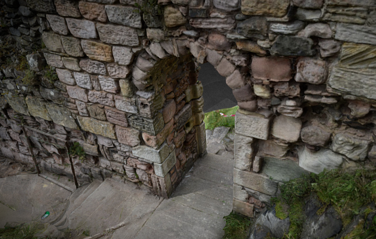
St Oswald’s Gate is written about as the entrance to the fortress of Bamburgh in the 8th century AD (Symeon HK, III. pg 37) and was very likely the route up onto the rock plateau since the earliest settlements. The present phase of work is investigating the entrance, the access routes up to the entrance and the structures and outworks built to control this route over many generations.


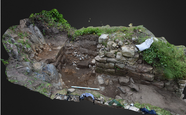
3D Model of The Tower of Elmund’s Well

One particular area of focus was the recovery of the site of the Tower of Elmund’s Well, named in records from the 13th century (Colvin, H. M. pg 556) and onto which a cottage was constructed in the late 18th century.

The outline of the cottage/tower structure was quickly revealed during the first phase of investigation by the removal of foliage and a modest volume of aeolian sand. One of the first exciting discoveries during 2022 excavation was the presence of two splayed lights (open window-like features) in two of the walls. The discovery of the top of a stone archway that formed the entrance to the well-room confirms both the depth of the basement, there must after all be depth to pass under the arch, but also suggest that the floor level cannot be too much deeper.


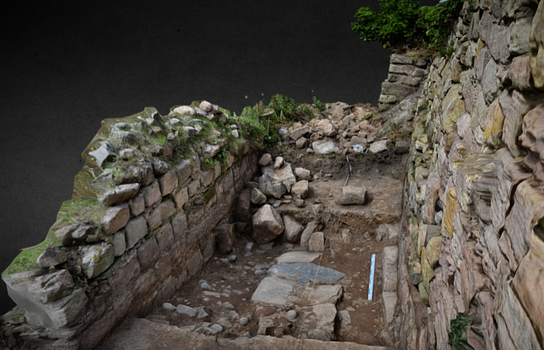
3D Model of the Postern Gate Trench 5D

The postern gate lies beyond St Oswald’s Gate and leads out to Bamburgh Village. The structure as uncovered was a single well-constructed feature of coursed squared masonry that ended abruptly and deliberately short of the rock. A further constructed face abutted the bedrock and the gap between the two faces a little more than 1m side formed what surely must have been a second gate.


3D Model of Trench 5E with possible foundation wall

Trench 5E was a new trench opened in 2023, sited outside of the wall with the postern gate and the outworks. It was placed next to a short length of wall that we investigated in 2022 to see if it had once extended further. It has revealed a stone alignment that extends parallel to the two standing walls. Those of the outworks and the short wall length. So far only the upper level has been uncovered, so it is possible that it could be either a wall top or a foundation or the surface of a narrow path.


We think being able to share these 3D models, alongside the traditional interim report, really helps others who have not been to site to visualise the structures and our progress to date.

Please check back soon to take a look at the preliminary masonry report that will add further detail to the 3D models above.


New early medieval building

It has been a busy few days on site in the West Ward. Weather has managed to vary between glorious and wet and windy but we have made good progress and at least one very exciting find. We have 11 post-holes in an L-shape close to the western trench edge and this must be part of a timber building that mostly lies to the west of the trench between it and the defensive wall.

IMG_5951

The post-holes can be seen in the centre of the photo. Nine are visible and two more are present in a pit close to the section edge.

The building sides exposed measure some 6m by 2m but the building is likely to be larger than that. We may be seeing most of the length north-west to south-east but the building is certainly a good bit more than 2m wide.

We are uncertain of its date at this time but it is unlikely to be later than the 7th century AD and could be 6th century. The is just room to explore ‘within’ it to see if we can recover trace of floor surfaces. Something to keep us busy over the next few days.


We are back digging at the castle

When we did our round-up of the 2019 Summer dig a few weeks ago we did say we that we had some news of work that would be happening over the next few months, so I think its high time we told you what it is! There have been a number of changes at the castle this year, and more are planned. Amongst these are additions to the experience of visiting the West Ward, where the old Trench 1 has been backfilled and landscaped, and now there is the intention to add more public activities from next summer. As our major excavation (Trench 3) rather sprawls over a substantial area of the ward it is rather in the way of this so following discussion with the castle, we are doing a staff dig to complete the excavation by next spring. We are able to do this due to a generous grant from the estate that will pay many weeks of wages and because we had pretty much reached he same level as Dr Hope-Taylor had managed in the 1970s, so all that remains is to excavate a sufficient sample down to the earliest occupation beneath the Hope-Taylor levels.

new hearth

Just started and we already have a new stone-lined  hearth uncovered

By adding this deeper sample we will have a full sequence from the prehistoric to the modern era. We will of course have to sample the earliest deposits over a much smaller area. This is necessary because of the time available but also unavoidable due to the need to step the area in for safety reasons due to the depth we need to reach. This could be as deep as 4m below ground level in places.

We will have a smaller team than usual so will not be able to do as many social media posts as we would like as we need to concentrate on the excavation, but we do intend to keep you informed as well as we can.

It will be the end of an era for the BRP but not the end of our work at Bamburgh as future projects are already being developed.

The Final Elegy of Trench 1

Before you read this blogpost, it is imperative you open this song in another browser tab to truly experience this post of bittersweet mourning and absolute elation that the trench is truly done.

About twenty years ago, the Bamburgh Research Project opened a trench in the northern end of the West Ward. It was one of the first trenches (along with trench 2) we opened in the Castle. The spot was chosen to focus on the early entrance to the Castle and hopefully trace the sequence of fortification in the outer ward, as some of the Norman wall was still extant. Saint Oswald’s Gate would have been the entryway during the Anglo-Saxon period, but became more of a back door during the Norman period. The archaeology in the trench was a bit shallower than trench 3 (our last remaining open trench), due to the bedrock and associated boulder clay exposed by erosion and centuries of use.

IMG_20190708_134543

Even though the bedrock was a starring character in the story of the trench, there was evidence of slots cut into it along with numerous pits and postholes cut into each other, as well as at least one robber trench where masonry was, shall we say, “appropriated.” What likely stood where we excavated was a timber (7th century), and later stone (pre-11th century), guardhouse or warden’s residence.

trench 1 overlay

The surviving post-Conquest wall would have been about a metre higher than it stands today, but even in its ruined form one can imagine how the view we now take for granted was obscured except for those patrolling parapets. The Norman remnants, skirted by the Armstrong-era low wall, seem to stand in the footprints of at least the timber defences, if not also where late Saxon masonry would have stood. During the early Anglo-Saxon period, the site was likely palisaded and patrolled along a box rampart, a log structure filled with rubble and clay.

66299396_2433750823351483_1563563911892959232_n

We reached out to some former staff members for pictures of the trench in progress that weren’t featured in the closing of the trench post, so join us for a last quick trip through the trench.

trench 1 2000

2000.

2005

2005.

time team 2010

2010 when Time Team were here.

2013 2

2013.

2016

2016.

IMG_20190708_153723

This week.

IMG_20190708_154536

One last look.

img_20190710_115420

As a bonus, here is a nearly-twenty-year-old low-quality picture of our director Graeme in trench 1 that was only preserved via phone camera of a computer screen and that we had to get by diving into the darkest recesses of former staff members’ hard-drives.

old graeme trench 1

We Are Legally Required Not to Make This Title a Pun About St. Oswald’s Arm

The Inner Ward of Bamburgh Castle holds many secrets, and one of the most interesting at hand (…sorry, couldn’t help it) is the church of Saint Peter/chapel of Saint Oswald. Across from the modern staterooms stands a small ruin. Don’t be fooled, however, because the ruins were modified during the Victorian Age! There seems to have been an intention to rebuild a chapel on the spot even in the 18th century, but it was never completed and dismantled early in the 19th century. It was extremely fashionable to have ruins on your property if you were wealthy, and if you didn’t have actual remnants of historical buildings, you could simply commission some. There was a certain romance in the decaying masonry of peoples long since gone. We call the false ruins found scattered on estates throughout the country “Victorian follies.” The folly that demarcates the holy space at the top of the Bamburgh rock does contain the tiniest bit of 12th-century Norman masonry in the far corner, but otherwise only preserves a rough guess at where the Anglo-Saxon period church would have stood. The Anglo-Saxon church is mentioned in a few key chronicles of the period, including Historia ecclesiastica gentis Anglorum (Ecclesiastical History of English People) written by the Venerable Bede. In Bede’s time, the church was dedicated to Saint Peter, but Norman records suggest the same site became the chapel of Saint Oswald.

Manuscript excerpt featuring Saint Oswald; man with brown hair, sceptre, and globe.

Excerpt from Spencer 1, folio 89 reverse. (New York Public Library.)

Oswald was son of a Bernician king who had been sent to exile after the death of his father; he was victorious over the numerous rival communities and kingdoms during his reign, and he was regarded as the overking of the English, called Bretwalda. The northern kingdoms of Bernicia and Deira were joined for perhaps their most successful stretch by Oswald. The royal city of this now-united-but-only-temporarily kingdom was Bamburgh, at the time called Bebbanburh. The origin of that name seems to stem from the name of the wife of Æthelfrith, descendant of King Ida who was the first recorded Anglian king of Bernicia (547AD). Oswald encouraged the Celtic Christianity brought by Aidan (from Iona but later founder of Lindisfarne), making the united Northumbria a Christian kingdom.

Bede’s Ecclesiastical History is also full of many juicy little morsels about Anglo-Saxon kings, and King Oswald is no exception. One anecdote of Oswald’s piety witnessed by Aidan, bishop-turned-saint, is recounted by Bede:

At dinner, the two men received word that outside a crowd of beggars had amassed hoping the king would spare some food. Oswald immediately sent his silver plate piled with food out to them and had the plate broken up and pieces given to each. Aidan was so pleased by such a gentle and generous king, he held the hand that had offered relief to the poor of his kingdom and blessed him that his arm and hand would never wither. When Oswald was defeated by Penda, last pagan king of the Mercians, his head and limbs were struck from his body. The arm and hand were eventually recovered and sent to Bamburgh, where they lay in a reliquary of silver.

img_20190701_123415

The apse encircling the 19th-century bell is the only extant Norman masonry.

In 1997, 2000, and finally in 2010, the BRP did some geophysical surveys of the area where the Victorian folly now stands; the first year involved survey of resistivity (which measures how an electrical current travels through the ground), the second was ground-penetrating radar, while the last involved both methods, this time with the help of Channel 4’s Time Team crew. The initial data were promising, suggesting a vaulted crypt might lay beneath the ruins. After subsequent excavation, numerous features on the church site were discovered and recorded, but none that matched the anomaly from the surveys. One theory is that the shape was actually a signature of the subsurface material that had been flipped when the data were compiled. The area did however suggest Romano-British occupation, medieval construction phases, and post-medieval disturbance during the Armstrong rebuild period. All in all, the trenches, although not containing a crypt with or without a 1,377-year-old hand, proved incredibly valuable in our understanding of some of the Inner Ward of the castle.

So was this where Saint Peter’s church actually stood? What happened to Oswald’s miraculously uncorrupted arm and hand? Well, we aren’t quite sure. As much as we love solving mysteries with archaeology, a mystery that continues to remain just out of reach tantalizingly urges us forward to reassess our approaches and previous interpretations.

Join the Bamburgh Research Project as part of the Festival of Archaeology

The Bamburgh Research Project (BRP) will hosting a weekend of free activities as part of the Council for British Archaeology’s annual Festival of Archaeology.

2019-PrintMain_Logo_CBA_WEB

Join the BRP on the 20th or 21st of July to explore 2000 years of activity at Bamburgh Castle on their annual excavation within the West Ward of Bamburgh Castle, Northumberland.

The BRP have been excavating through 2,000 years of occupation at Bamburgh Castle. As we excavate, we undertake environmental sampling of the different archaeological layers. These are processed on the trench-side where bones, seeds, charred remains and small artefacts (including coins, gold-filigree decoration and beads) are recovered.

Festival 5

As part of the Festival of Archaeology the BRP are hosting four half-day sessions where members of the public can work with our Environmental Supervisor to process our samples and record the material we recover. This will include specialist training with a flotation tank, tuition in recording the processed material and identification of archaeobotanic material in our on-site lab funded by the Mick Aston Archaeology Fund.

To book your place simply visit the Festival website and follow the instructions: sign-up to the BRP Festival event


Plans for the Summer

DSC00253

As it is only a matter of weeks now to the start of the excavation at Bamburgh Castle this seems a good time to write a little about our plans for the season. It promises to be a busy few weeks as we have funding from the Society of Antiquaries of London to assess the bulk of the metalwork from the West Ward.  We will need to prepare all of this to be safely transported to our conservator in addition to the normal excavation and post excavation work.

Pre-season update

The section of the Hope-Taylor Trench as it joins with Trench 3

In Trench 3 we are close to revealing the extent of a new structural surface that appears to be rather substantial. It is made of rounded beach cobbles and we revealed several metres of this in a narrow sondage in previous season. The question remains what is this – part of a building? Or is it a yard or path? It appears from the section (photo above) that it is on a similar level to a stone foundation for a timber structure that Brian Hope-Taylor revealed in the 1970s that may be associated with a socket stone. So we have no doubt that some buildings are present in this phase, but are we looking at more metal working similar to the phase above? We are determined to get some answers this summer.

2018 Funding Success with the Society of Antiquaries of London

The Bamburgh Research Project are pleased to announce that the Society of Antiquaries of London have kindly awarded us £4700 to undertake continuing post-excavation analysis of the material recovered within the West Ward of Bamburgh Castle.

SOA Logo

The project ‘Forging Castle Space’, will focus on the metalwork recovered from early medieval contexts in Trench 3. The funding will allow us to assess and plan the conservation of 7,200 fragments of early medieval metalwork, spanning the 8th-11th centuries, plus conserve a 25% sample of all styca coins recovered.

BRP image

The Bamburgh Bird. One of the many early medieval artefacts recovered from Trench 3.

Upon completion of the project the metalwork will be better understood in terms of its function, origin and date, plus its purpose for deposition within an associated building, likely used for working metal (You can read more about the building here: Castling, J. and Young, G. L. 2011. A 9th Century Industrial Area at Bamburgh Castle, Medieval Archaeology, Vol. 55, 311-317). This data will allow us to better understand the function of the building, its associated area and the broader 8th-11th century horizon in this area of the castle. The data generated will also inform ongoing excavation and aid us in our attempt to contextualise earlier excavations (1959–74) for which we only have a partial archive surviving.

IMG_0987

9th-10th century ‘metalworking’ building

The long-term goal is to establish the character and significance of early medieval activity, as this was pivotal in creating the spatial and material precedent upon which the post-Conquest castle complex developed.

We have already made great strides towards understanding this period in the West Ward, as we have recently completed the post-excavation analysis of Trench 8, which sits immediately adjacent to Trench 3. Funding from the Royal Archaeological Institute has enabled us to determine a stratigraphic sequence from the modern to the Roman period using the artefacts recovered and C14 dates to identify and date contexts. You can learn more about this project here: Trench 8 RAI Grant.

If you would like to join us this season to help us undertake the excavation of this fascinating site or work more specifically with our post-ex team (artefacts and environmental material) please visit our website for more information: http://www.bamburghresearchproject.co.uk


Launch of our 2018 Archaeology Field School


Booking details are now available for our 2018 field school season, which runs from June 17th – July 20th.  The field school will operate out of Bamburgh Castle and we are offering two programmes:

Excavation and Post-Excavation or Post-Excavation only

You can book anywhere from one to five weeks. However, we recommend booking two weeks minimum for a well rounded experience. Our dates are listed below:

  • Week 1: June 17th- June 23rd
  • Week 2: June 24th- June 30th
  • Week 3: July 1st- July 7th
  • Week 4: July 8th- July 14th
  • Week 5: July 15th- July 20th

Student spaces are limited, so we encourage you to book your place as soon as possible.

Tuition is £275 per week, which will cover all on-site excavation and post-excavation activities. You can learn more about what this covers by visiting our website.

Accommodation must be booked separately. There are many options for accommodation in the area to suit every budget and we are happy to offer suggestions. However, we do encourage all participants to stay in close proximity to BRP staff, as this allows staff and students the opportunity to get to know one another in a social setting and there are friendly faces around should you need a helping hand. This year our staff will be staying at Budle Bay Campsite

Note: There have been several changes to the field school such as our training schedule and when you are expected to arrive. Even if you have booked in years past we encourage you to read-through the updated website pages.

If you have any questions please do not hesitate to get in touch.

The Trench 3 ‘doughnut’ has been lifted

An unusual worked stone that we have been referring to as the ‘doughnut’ has been a familiar feature in the southern part of Trench 3 for the last few seasons at Bamburgh Castle. It was first revealed in 2011, but it took two further seasons to lower the ground surface around it sufficiently for its unusual form to become apparent.

IMG_0930

The metalworking building roughly outlined by the stones used for its foundations with the top of the ‘doughnut’ just visible 1m outside the west wall, in the lower- left of the photo.

It lay immediately west of the metalworking building and is broadly contemporary with that structure, which would make it middle 9th century AD in date. The wear pattern on the side suggests that the top third of the stone was uncovered above the surface for sufficient time for it to wear and erode more than the base which appears to have been set into the ground. We believe therefore that it was inserted into a cut which we have struggled to see.  The presence of a small number of what are likely packing stones reinforces this interpretation.

Stone1

As removed sitting right side up. The unusual form and perforation is visible (scale 0.5m demarked with 10cm units).

The stone is difficult to interpret and has been suggested as a socket for a timber pivot, a socket for a standing cross, which would be exciting but sadly is rather unlikely give its circular shape. It could also to have been set as a soakaway, given that it is perforated all the way through. Now we have lifted it and examined it seems likely that it started life as a mortar as the upper part of the perforation is smooth and the lower crudely cut through. Our best guess is that it was a large mortar re-used as a pivot stone.

Stone 2

In the side view the more eroded upper third of the stone is seen to the right (scale 0.5m)

Stone3

The base of the stone. It is just possible to see tha the last part of the perforations is quite crudely chiselled unlike the upper part which is finished or worn to be relatively smooth. Also just visible are a series of shallow dimples unevenly arranged around the hole (scale 0.5m).