In early 2023 the BRP was awarded funding from the Castle Studies Trust to undertake a series of non-invasive surveys to provide additional context to the outworks of Bamburgh Castle, focussing on St Oswald’s Gate and the Tower of Elmund’s Well. You can find out more about this area in our earlier blog posts (here’s a good place to start: Director’s End of Season Excavation Round-up).
We are now finalising the associated reports and sharing these ahead of releasing our interim excavation report. The next report we are sharing details a geophysical survey that we undertook with Dr Kristian Strutt of the Archaeological Prospection Services Southampton University exploring the environs of Bamburgh Castle.
Dominic Barker using the Bartington Grad 601-2 instrument on the Cricket Ground (photo: K. Strutt)
The Geophysical Survey Results
The survey utilised magnetometry, resistivity and Ground Penetrating Radar (GPR) survey of areas of the Cricket Ground to the west of Bamburgh Castle. The results indicate the possible presence of a large ditch, some 45m across, immediately to the west of the outcrop, in addition to trackways, walls and other features in the survey area.
One of the principal questions we were hoping to address with the geophysics was if the castle ditch extended across the sports field at the base of the castle rock. A ditch cut through sandstone, can been traced in the area of the modern entrance that is at the site of the 12th century gate. This feature extends across the front of the castle as far as the sandstone ridge was present above ground. The results of the GPR do seem to strongly indicate a large feature in the area where we would anticipate the castle ditch to be and the magnetometry and resistance surveys do seem to support this. It is intended to conduct further fieldwork, starting with coring, to confirm this.
Earth resistance survey being carried out by BRP volunteers (photo: K. Strutt)
In addition, to the probable ditch feature, several features seen on the 1st Edition Ordnance Survey appear to be picked up on the surveys. Two trackways are evident, that lead to St Oswald’s Gate and to a cleft in the castle rock called the ‘Miller’s Nick’, which allowed people to scramble up to the West Ward in the 19th century. The second is an S-shaped path that meandered towards the area of St Oswald’s Gate, perhaps originally skirting around the edge of the ditch feature. One further route-way or path extends across the field parallel to the road in the village to the south, called the Wynding, that appears from records to have had a medieval origin. This path runs alongside a linear plot boundary and field boundaries and it will be interesting to see if more can be made from a number of anomalies that can be seen within the enclosure areas to the south and west of the plot.
The resistivity and ground penetrating radar surveys so far cover a more limited area, due to time constraints and public access. There is an area of low resistance that lies in just the area that the ditch would lie and matches up to the path towards the Miller’s Nick. The enclosure areas picked up in the magnetometry to the south-west also seems to be present on the resistivity. Notably, there is a high resistance feature that the S-shaped pathway may curve deliberately to avoid at the south part of the plot. A further T-shaped high resistance feature is present in the north-east extending from the area of the modern pavilion that will bear further study. The GPR further reinforces the presence of some of these features and indicates some depth to the anomaly that is interpreted as the ditch, though the signal attenuates before it could indicate a true depth.
Interpretation plot of all three surveys, labels link to the report text (Airbus 11/05/23)
It provides more information about the background to the site, detail about each survey technique and a breakdown, with useful maps and figures, about what was discovered.
In our forthcoming interim report we use this information to enhance our understanding of the castle within its landscape context and explore in more detail what some of the features identified in the survey might be.
The geophysical survey described in this blog has been funded by the Castle Studies Trust.
This charity is entirely reliant on donations from the public. To help the Trust to continue funding this kind of research, please visit https://www.castlestudiestrust.org/Donate
Archaeology is not all about digging. In order to turn the data gathered through excavations or surveys (for example) into information that can be used to interpret a site and/or plan further investigations, archaeologists must process this data during the ‘post-ex’ phase.
This includes recording the artefacts recovered, processing the environmental samples taken, digitising the drawings and survey information, for example. This work generates a physical and digital archive, which connects all the pieces of information together. It takes far longer (in most cases) than the actual field work and often takes place in the lab or at the desk.
Post-Ex at the Bamburgh Research Project
Here at the BRP we have generated a lot of post-excavation work in the last 20 years. We undertake much of the initial post-ex on site, where we wash and process the small and bulk finds, we process our environmental samples and we catalogue much of the records and photographs we take. However, there is still much work that is undertaken during the off-season by our staff and more that is sent away for specialist analysis. We thought this year we might bring some of this ‘behind the scenes’ work back to the Castle and share it with a small cohort of interested individuals.
What is the Post-Excavation Taster Week?
We offer quality training in archaeology with an emphasis on practical hands-on experience. The post-excavation taster week will use the BRP’s extensive archive, which consists of material from the prehistoric to the medieval periods, as the basis for an introduction to the different post-excavation techniques and research methodologies employed by the project.
We are still planning the daily schedule but the week will include:
a general introduction to finds processing (bulk and small finds)
guided tour of Bamburgh Castle, related Anglo-Saxon burial ground and the new ossuary and Bamburgh Bones exhibition
learn the process of creating pottery from clay to shaping to firing from a specialist
Please Note: we are also in the process of organising tuition by an osteoarchaeologist for September TBC.
Who is it for?
Our training is open to people of all skill-levels and abilities, with particular interests accommodated where possible. We particularly wish to offer a fun and educational experience to beginners and non professionals.
Please get in touch with us if you have any questions about access, facilities, etc.
BRP is open to anyone aged 18 and over.
Who will be teaching me?
Professional field archaeologists and post-excavation specialists.
Learn about ancient textiles
How much does it cost?
The post-excavation taster week costs £350 pp and covers 5 days of training in a small group of between 6-8 people. This covers the cost of the tuition, tours and the trip to Lindisfarne.
How do I book a place?
Please visit the BRP’s website and take a look at the Post-Ex Taster Week page. At the end of the page is the details on how to book and pay for your place.
PLEASE NOTE: the week will only run if the BRP receive enough bookings to make the week viable (more info on website).
In early 2023 the BRP was awarded funding from the Castle Studies Trust to undertake a series of non-invasive surveys to provide additional context to the outworks of Bamburgh Castle, focussing on St Oswald’s Gate and the Tower of Elmund’s Well. You can find out more about these in our earlier blog posts (here’s a good place to start: Director’s End of Season Excavation Round-up).
We are now in the process of finalising the associated reports and outputs and will be sharing these over the next few weeks ahead of releasing our interim excavation report. One of the surveys we undertook was a preliminary assessment of the standing masonry elements in the outworks, which will sit alongside the excavated archaeological report. To support this we also commissioned several photogrammetry surveys to create 3D models of the standing outworks and internal structures of the Tower of Elmund’s Well.
We are really excited to be able to share these with you now. Below, you can click each photo to take you to the online model, which will allow you to explore each area in detail.
3D Models of Bamburgh Castle’s Northern Outworks 2023
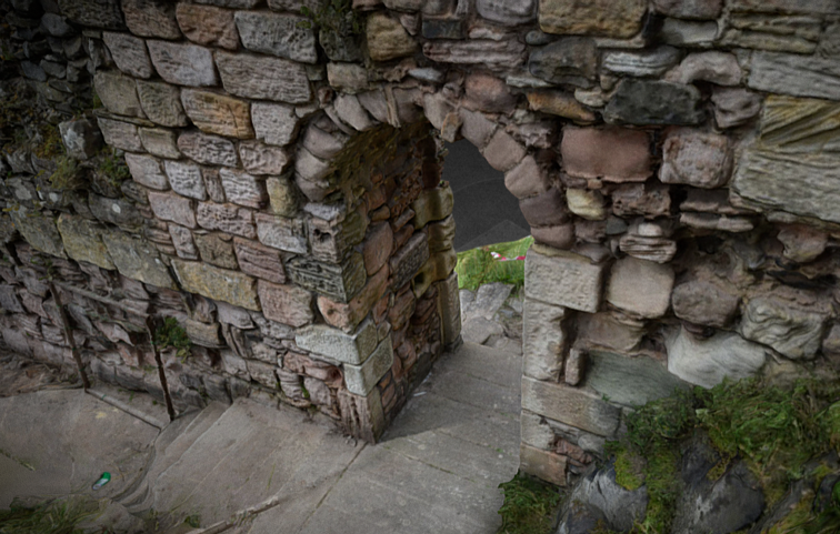
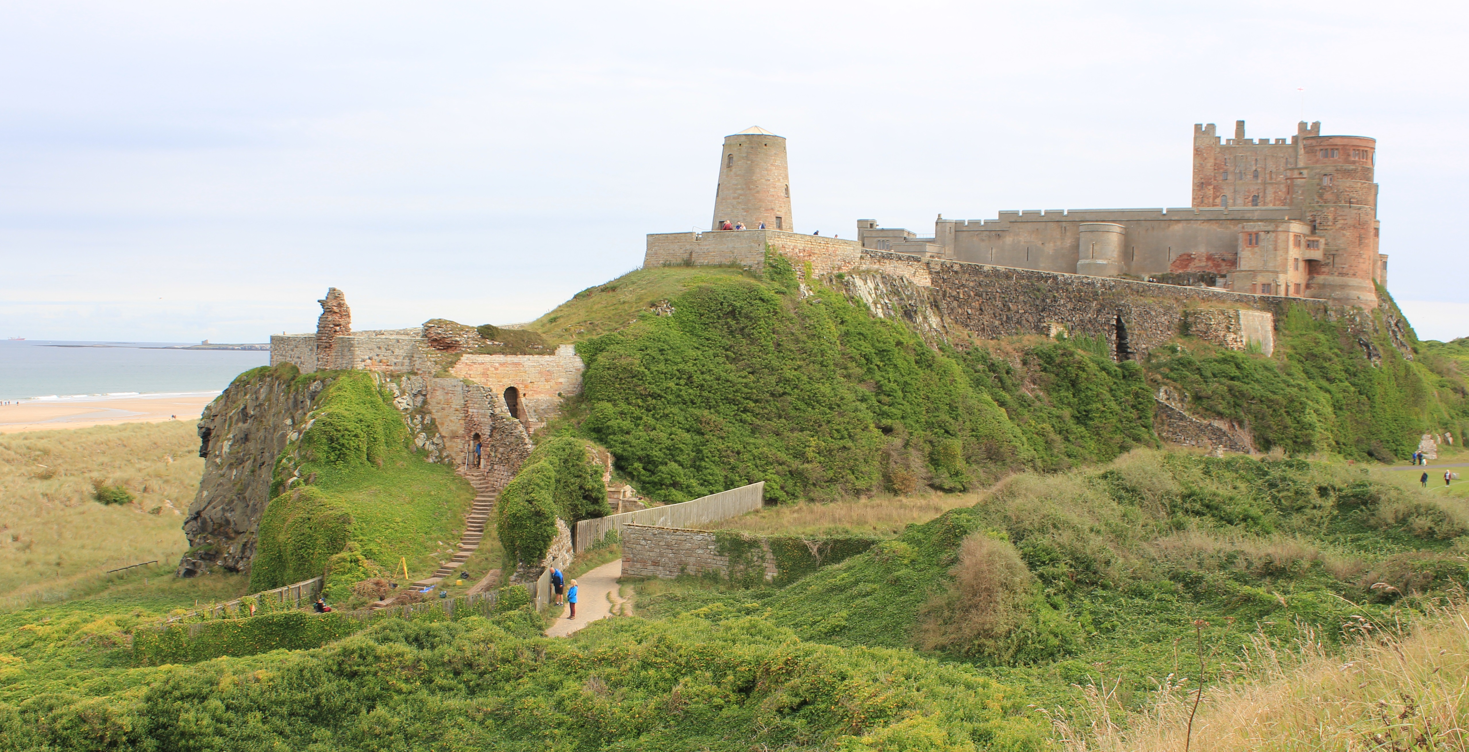
St Oswald’s Gate is written about as the entrance to the fortress of Bamburgh in the 8th century AD (Symeon HK, III. pg 37) and was very likely the route up onto the rock plateau since the earliest settlements. The present phase of work is investigating the entrance, the access routes up to the entrance and the structures and outworks built to control this route over many generations.
One particular area of focus was the recovery of the site of the Tower of Elmund’s Well, named in records from the 13th century (Colvin, H. M. pg 556) and onto which a cottage was constructed in the late 18th century.
The outline of the cottage/tower structure was quickly revealed during the first phase of investigation by the removal of foliage and a modest volume of aeolian sand. One of the first exciting discoveries during 2022 excavation was the presence of two splayed lights (open window-like features) in two of the walls. The discovery of the top of a stone archway that formed the entrance to the well-room confirms both the depth of the basement, there must after all be depth to pass under the arch, but also suggest that the floor level cannot be too much deeper.
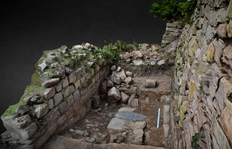
The postern gate lies beyond St Oswald’s Gate and leads out to Bamburgh Village. The structure as uncovered was a single well-constructed feature of coursed squared masonry that ended abruptly and deliberately short of the rock. A further constructed face abutted the bedrock and the gap between the two faces a little more than 1m side formed what surely must have been a second gate.
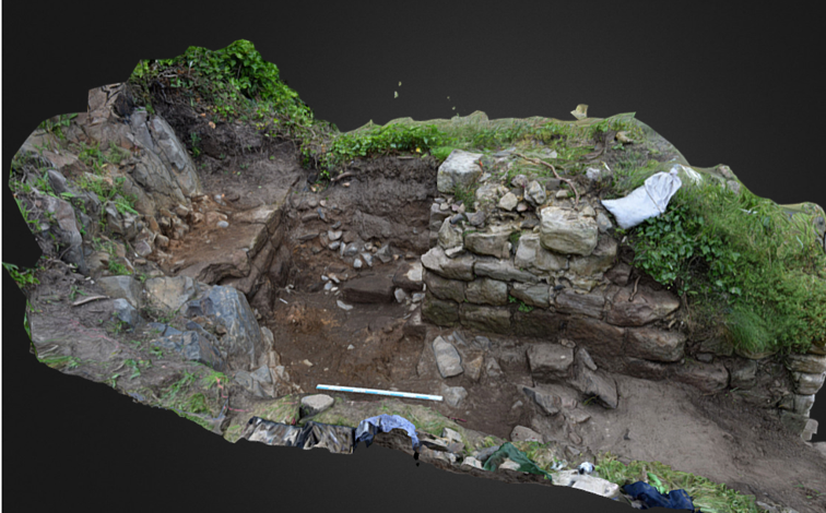
Trench 5E was a new trench opened in 2023, sited outside of the wall with the postern gate and the outworks. It was placed next to a short length of wall that we investigated in 2022 to see if it had once extended further. It has revealed a stone alignment that extends parallel to the two standing walls. Those of the outworks and the short wall length. So far only the upper level has been uncovered, so it is possible that it could be either a wall top or a foundation or the surface of a narrow path.
We think being able to share these 3D models, alongside the traditional interim report, really helps others who have not been to site to visualise the structures and our progress to date.
Please check back soon to take a look at the preliminary masonry report that will add further detail to the 3D models above.
The focus of our work over the last three seasons has been the investigation of the outworks beyond St Oswald’s Gate and in particular the Tower of Elmund’s Well and our ongoing search to find what remains of the well within it. You can read our previous seasons excavation to round-up to here to see where we started at the beginning of this year’s dig season.
Tower of Elmund’s Well
We have been surprised, delighted and even a bit astonished just how much of the tower survives even if this discovery has involved moving a lot of rubble! The stairs down into the tower, by the end of the season, had passed through the archway and into the tower room itself. This would suggest that although we have yet to reach the floor there is less and less space for many further steps before we will reach the far wall so we feel that the floor is probably no more than 1 metre deeper, and hopefully somewhat less.
This season, with the fence that surrounds the outworks moved back a little to allow for more space, we were able to start a trench outside of the turret to the seaward side to expose the outside of the wall face.
The tower wall before the seaward side was exposed.
This was to give us a proper understanding of the width of the wall, the top of which had been altered substantially it seemed when the tower was converted into a cottage. Here, less than a metre down, we found that the wall survives wider than it appears at the top, where some facing stones had been removed. As we excavate deeper (next season) it is hoped to identify buried ground surfaces, now covered by the windblown dunes, and perhaps even the ground surface contemporary with the tower’s construction.
One of the more interesting finds from within the backfill within the tower was a well constructed metal bucket. It is of course tempting to see this as associated with the well – perhaps the last well bucket that was in use! Of course there is every likelihood that it was just another item disposed of in the backfill, along with a car wheel and other household items, but we can still hope to identify some of the machinery needed to work the well abandoned at floor level.
Allen with the bucket!
Postern Gate and Wall
This season also saw further work on the external postern gate that leads out to the village. This involved continuing the excavation immediately behind it to uncover more of the structure. The intent for this was to uncover more of the wall to help interpret it, perhaps recover some datable finds, and if fortunate, see if we could find the level from which it was constructed. We had certainly not at all expected to discover what we actually found which was a gap in the wall that was deliberate. The gap was not there because the wall had been robbed away as it had deliberately constructed faces. The width and form of this strongly suggested a second narrow gate.
The gap in the postern wall that must be a second and perhaps earlier postern gate
The outside face that looks out to the village had been blocked by a single layer of masonry to close off the gap. It was also evident that it was quite high up (on the outside) as it bottomed onto a spur of the bedrock. This means the gate was at ground level on the inside but was a couple of metres above it on the outside. There is no trace of a stair up to it, so it seems likely that there would have been a wooden stair, which perhaps would have made it a little more defensible as it could be discarded in the face of an enemy.
It does not seem to make sense that there would be two posterns next to each other so its tempting to see one as replacing the other. As the current path leads to the one that is still, in its way in use, its natural to assume that this is the later one, but this may be false as we simply cannot be sure the positions of the path in early times.
Trench 5e the new feature that is something of a flashback to T3
This season we opened a new trench on the outside of the wall with the postern gate (now two gates). The new trench was next to the short length of wall that we investigated last season to see if it had once extended further. Rather disappointingly we found that it confusingly just ended rather abruptly with no trace of foundations extending further, or even of a robber cut where once could have been removed. The new trench was opened between that wall and the postern wall and thankfully has proved to be much more interesting.
It has revealed a stone alignment that extends parallel to the two standing walls. So far only the upper level has been uncovered, so it is possible that it could be a wall top (or foundation) or just a surface like a path. It is made of dolerite and sandstone and in this, along with its width and general form, it is very reminiscent of some of the early medieval features the we saw within Trench 3 (within the castle). Here these features had been interpreted as stone foundations for timber walls. It is then very intriguing to wonder if we are seeing the same kind of feature here in the outworks, and even more interesting should the feature prove to be of similar date. One of the questions we asked ourselves at the beginning of the work on the outworks was – could we find any evidence for structures and arrangements from the early medieval period? After all we know the entrance was in use from this time and likely centuries earlier, so there must have been access routes and perhaps structures associated with this use and also control of the small port.
The new linear structure between the two standing walls that could perhaps be a wall base, with a possible ground surface to the left in the photo.
Geophysics
We were very fortunate to have a geophysical team from Southampton University with us for a few days in our final week. This was a part of the work on understanding and recording the outworks at St Oswald’s Gate that has been generously funded by the Castle Studies Trust. We will report in much greater detail on this and on the 3D recording and building survey in future blogs, as the results are worked through. As of now we have seen just enough information from the geophysics undertaken on the green in front of the castle to know there will be lots to discuss, including what at first sight may be some early features on the far side of the green. Not bad when we really only hoped to find trace of a ditch extending towards Oswald’s Gate and the port area.
Bookings are OPEN for a 1 week post-excavation taster.
What is post-excavation?
Archaeology is not all about digging. In order to turn the data gathered through excavations or surveys (for example) into information that can be used to interpret a site and/or plan further investigations, archaeologists must process this data during the ‘post-ex’ phase.
This includes recording the artefacts recovered, processing the environmental samples taken, digitising the drawings and survey information, for example. This work generates a physical and digital archive, which connects all the pieces of information together. It takes far longer (in most cases) than the actual field work and often takes place in the lab or at the desk.
Post-Ex at the Bamburgh Research Project
Here at the BRP we have generated a lot of post-excavation work in the last 20 years. We undertake much of the initial post-ex on site, where we wash and process the small and bulk finds, we process our environmental samples and we catalogue much of the records and photographs we take. However, there is still much work that is undertaken during the off-season by our staff and more that is sent away for specialist analysis. We thought this year we might bring some of this ‘behind the scenes’ work back to the Castle and share it with a small cohort of interested individuals.
What is the Post-Excavation Taster Week?
We offer quality training in archaeology with an emphasis on practical hands-on experience. The post-excavation taster week will use the BRP’s extensive archive, which consists of material from the prehistoric to the medieval periods, as the basis for an introduction to the different post-excavation techniques and research methodologies employed by the project.
We are still planning the daily schedule but the week will include:
a general introduction to finds processing (bulk and small finds)
guided tour of Bamburgh Castle, related Anglo-Saxon burial ground and the new ossuary and Bamburgh Bones exhibition
guided visit to Lindisfarne and Ad Gefrin
Please Note: we are also in the process of organising a visits by a Specialist but these are yet to be confirmed.
Who is it for?
Our training is open to people of all skill-levels and abilities, with particular interests accommodated where possible. We particularly wish to offer a fun and educational experience to beginners and non professionals.
Please get in touch with us if you have any questions about access, facilities, etc.
BRP is open to anyone aged 18 and over.
Who will be teaching me?
Professional field archaeologists and post-excavation specialists.
How much does it cost?
The post-excavation taster week costs £300 pp and covers 5 days of training in a small group of between 6-8 people. This covers the cost of the tuition, tours and the trip to Lindisfarne.
How do I book a place?
Please visit the BRP’s website and take a look at the Post-Ex Taster Week page. At the end of the page is the details on how to book and pay for your place.
PLEASE NOTE: the week will only run if the BRP receive enough bookings to make the week viable (more info on website).
The Bamburgh Research Project will be taking part in an online talk to discuss the archaeology of the Last Kingdom.
Coinciding with the release of The Last Kingdom: Seven Kings Must Die, this event is designed to appeal to fans of the series, highlighting the ‘real’ history and archaeology behind the show.
The event is free for anyone to attend, and a recording will be made available on YouTube at a later date.
The Last Kingdom has proved incredibly popular, so we thought it was about time we explore how the story holds up against the archaeological and historical evidence.
The story of Uhtred from the books begins along with the Viking Age and with Uhtred as a boy at the time of the Viking Great Army. It then moves quickly on to the time of Alfred the Great. We have seen from the first blog that there was a real Uhtred whose life inspired the story but that he was from a much later time (the end of the 10th and early 11th centuries). In this blog we will look at the beginning of the books and see if we can find connections with the Bamburgh Family from this earlier time in the real history of the period.
The north after the creation of a Viking kingdom in Yourkshire (wikicommons)
The first Viking Age ushered in a period of great change across the British Isles, overturning once settled political structures. It began with a long period of raiding extending over more than two generations and then in the mid 9th century the character of these attacks changed when large raiding forces were confident enough stay and over winter. Intentionally, or just as a consequence of their long term presence, these forces now became part of the power politics of the age and led ultimately to substantial settlement and the creation of Viking dominated kingdoms. This process began with the arrival of what the chroniclers called the ‘Great Heathen Army’ in the kingdom of East Anglia in AD 865. The sudden arrival of this force provided a very different challenge to the kind that the Middle Saxon kingdoms were uses to, and this quickly resulted in a degree of collapse of some of the power structures of the day. East Anglia was taken off guard and gave treasure and horses to the army, almost certainly hoping that they would leave, a policy that did work for a time.
It proved to be a particularly bad idea for the Northumbrians where two kings had been contesting the throne, meaning that there were divided loyalties to be exploited. The great army made there way north and attacked, seizing hold of the great city of York. The king of Northumbria on the throne at that time was called Aella having recently displaced a king called Osberht. One source suggests they were bothers but this is perhaps unlikely as others state that Aella was something of a usurper from an obscure royal line.
York was a hugely important city for Northumbria, being the seat of the archbishop and increasingly a major trading centre. The presence of wealthy merchants, and likely also a royal centre that had been stocked up with food for the next royal visit, would have been a tempting target. The Great Army seem to have intended to overwinter there as it was a well supplied site with a defensive perimeter. This situation was seen by the Northumbrians as so dire that both rival kings put there differences aside in order to fight to retake the city in the midst of winter. They attacked in the New Year of 867. The battle seems to have gone well for the Northumbrians at first, as they successfully broke into the city, but were unable to take advantage of this and it ended in disaster. The chronicle describes how those that had made it into the city were cut off before being killed or captured, leading to the collapse of the Northumbrian force with those that could making their escape fleeing. Of the two rival kings, Osbert was killed in the battle and Aella was reported as taken captive and then later put to death. Lurid tales from later legend describe his death as a human sacrifice. It is not at all certain that this was true, and many modern scholars seem to be sceptical, but we do have accounts from Arab sources of sacrifice of slaves being conducted by Vikings, so its by no means impossible.
A Thor’s Hammer pendent, of the few apparently Viking Age cultural items found at Bamburgh
In the aftermath of the battle the Viking army placed a puppet ruler called Ecgberht on the throne of Northumbria, to do their bidding in their absence. They then went south to raid other kingdoms. This worked for some five years before the Northumbrians rebelled, forcing the Viking army to return. In the end Northumbria was split along the lines of the old kingdoms that had, centuries before, come together to form it. Large tracts of the lands south of the Tees were divided up by the Viking force who settled and farmed the land. In the north, a rump of the kingdom north of the River Tees maintained its old kings for a while longer.
What was Bamburgh’s role in these turbulent times?
In the Last Kingdom books Uhtred is born into a family that are the hereditary rulers of the palace fortress of the kings of Northumbria. In history we know that it was from Bamburgh that the early kings of Bernicia ruled, from the middle of the sixth century, and that it remained one of the foremost centres until after the Norman Conquest. So there is no doubt that Bamburgh was and remained an important place throughout these times. We are told something of the arrangements by which important royal sites like Bamburgh were administered from annals and writings of the period.
In the absence of the royal court a palace like Bamburgh would have been administered by an important official called a reeve. It is almost certain that such figures were appointed by the king, but we cannot be certain that some roles did not become somewhat hereditary over time. It is frustrating that we have so few documents and references detailing how the governmental system of the Northumbrian Kingdom was administered, and not much more regarding the Northumbrian aristocracy- the warrior class from which such officials would have been drawn.
The records, as far as we have them, do let us piece together something of the aristocracy and offices that existed within the Northumbrian kingdom. Leaving aside the senior churchmen and Archbishop of York and thinking of the secular administration, the highest of these officials appears to have been the Patrician (in Bede’s Latin – Patricius). The Historian David Rollason has suggested that this was held by only one person at a time and we may be able to look at is as equivalent to a similar top role in the Merovingian court (France), called there the ‘Mayor of the Palace’. So we can imagine a top minister and chief advisor to the king. Next in status appears to have been the Ealderman and the historian Alan Thacker has suggested that some eight of these were present in Northumbria at a time. These were great lords, some even of royal descent (or the descendants of older royal dynasties that had lost their royal status) that may have governed a region or district. In later times this rank came to be associated with the title of Earl, a name borrowed into Old English from Old Danish. Beneath the Ealdermen were royal thegns – or gesiths – high ranking warrior aristocrats who held office at court or in the royal army. The reeves that ran royal palaces were likely drawn from this tier of society. We hear from the Life of St Wilfrid that one of these was the administrator of the Royal Palace of Dunbar at the time of King Ecgfrith, when the king instructed him to imprison Bishop Wilfrid there.
In the 10th century the ruler of Bamburgh was referred to as a ‘high reeve’ and in the 11th century its rulers were often called Ealderman or Earls. So its possible that a site as important as Bamburgh may have had a reeve of particularly high status drawn from the highest levels of society just below the kings themselves.
Kings of the North after AD 867
We can trace the royal line of the north – that ruled what is now Northumberland and Durham, and likely parts of the north west of the Pennines, into the last decades of the 9th century after the partition of the kingdom and the creation of a Viking kingship in York.
He had clearly not come recently to power and was noted (in the history of the Church of Durham a text preserved at Durham Cathedral that has much information from the early medieval period) as a friend and ally of Alfred the Great who died in 899. The short note that tells of his death (preserved as a kind of historical apocrypha by the Church of Durham) tells us he was murdered by another great noble of the north.
We have the names of three kings following Aella. Ecgberht, the puppet king placed in power by the Great Army and two of his successors who, it seems, successfully reasserted some independence for the lands north of the Tees. These were likely descendants of the royal house (though perhaps a rather extended royal house) if not necessarily the children of the two rival kings who died in 867.
The Bamburgh ruling house appears in the historical record at the beginning of the 10th century. The first of the Alderman/High Reeves whose names are directly associated with Bamburgh, and who were clearly rulers of great substance within the region, is named Eadwulf. Annals in England but also significantly as far as Ireland noted his death in AD 913. The chronicler Aethelweard names him as reeve of Bamburgh, demonstrating the link to the royal place dates from at least this period. He was clearly important enough for his death to be recorded far and wide and it is also fascinating and informative that the titles used for him in the Irish annals were those used by them when reporting the death of the old kings of Northumbria. Proof if any were needed of his status and power.
The appearance of the Bamburgh family
Assuming Ecgberht II ruled for several years that would take us very close to the time that Eadulf was the important ruler and ally to Alfred the Great. This does not mean that Eadulf was Ecgberht II’s formal successor, or direct descendent, but it may suggest that he inherited the role of the pre-eminent ruler of the lands to the north of the Tees by some form of arrangement or even by the fact of being the most powerful of the magnates of the region. This is not much removed from the little we know of the contested royal successions we see between rival branches of the royal dynasty in the 8th and earlier 9th centuries. At that time ambitious potential heirs seem to have competed for power by cultivating support from other powerful figures that included great lords and the major Bishops. Perhaps Eadwulf arrived in power in a similar way being a substantial land owner with a military force and the backing of some other important players.
One thing that does seem certain is that from the first Eadulf taking power north of the Tees, with few exceptions, power lay in his hands and his successors, who were his descendants. The nature of rule in the north changed and the era of competing dynasties was over as succession stayed within the family and seems in the main to have been orderly.
Where did Eadulf come from?
Can we then see Eadulf as the successor of one of the extended competing branches of the royal dynasty, who successfully did away with rival branches, or was he just an outsider without any sense of a legitimate claim who took control through force? There is a surviving text that claims to preserve his family origins. This is a manuscript now at Cambridge University Corpus Christi College – called MS 92. It contains a continuation of an annal by John of Worcester that preserved a series of additional documents tacked onto the end and one of these was the genealogy of Earl Waltheof, a descendent of the historical Uhtred (see our previous blog) through the female line. This genealogy names our first Eadwulf (who died in 913) as the son of a daughter of King Aella, and so a descendant of his dynasty through the female line. It is not without its problems as the dynastic claims predating Aella look less than secure but the decent from Aella to the later Waltheof are completely consistent with what we know from other records and as a document it is the only one we have that links the parts of this dynasty together consistently.
This still leaves us with many questions but it does seem to give an origin story for the Bamburgh Family that we can then trace right through the 10th and 11th centuries. We will look at this story and how it plays out in future blogs and indeed come back to this Aella connection as it may offer some important insights into the politics of the 10th century.
We are planning two different activities this year – the normal excavation and a new post-excavation week
The Summer excavation season will be 3 weeks in July 2023
We will be continuing our excavation on the outworks at St Oswald’s Gate. The dig will run for three weeks in July 2023, starting Sunday 2nd of July. The aim is to get information up on the website and bookings open very early in the New Year. If anyone wants to be added to the contact list to be notified as soon as the info and bookings go live feel free to email us at graemeyoung@bamburghresearchproject.co.uk
We have had two really good seasons on this site already and made some fascinating discoveries – such as the survivng stone arch into what must be the wellroom at the base of the Tower of Elmund’s Well (check out some of the blogs below for reports on the work so far). This year we will finish the site and find out what trace is left of the well itself.
What is the Post-Excavation Taster Week?
In addition to the normal excavation season, we will also be offering a Post-Excavation taster Week which will be an introduction to work on the archive from previous seasons. This includes recording the artefacts recovered, processing the environmental samples taken, digitising the drawings and survey information. This work generates a physical and digital archive, which connects all the pieces of information together. It takes far longer (in most cases) than the actual field work and often takes place in the lab or at the desk.
We are still working out the most appropriate date for this (week starting the week of 8th May is very softly pencilled in at the moment) but as with the excavation, details will follow soon and again you are welcome to ask to be added to the list to be notified (graemeyoung@bamburghresearchproject.co.uk) as soon as bookings open.
We always tell students and visitors that archaeology has way more paperwork involved in it than you see in popular culture portrayals. In addition to myriad paper forms and their increasingly digital counterparts, we also rely heavily on labels and labelling conventions that are used in every department on site.
Tools of the trade.
Our trusty Sharpie is always on hand for label emergencies. (Sharpies are also like currency on a dig, you protect them and hand them over only occasionally and with great suspicion of those you loan it to.) What may seem like normal paper beside it, however, is a little bit of high-tech stationary: it’s known colloquially as Tyvek, which is technically a trademark in the United States, but has become a generic name for the type of material our labels are made from. This phenomenon is known as “generification,” where a brand becomes a generic term, thus putting the brand’s legal right to their name in jeopardy. For example, plasters in the UK are called “band-aids” in the US, named for the brand “Band-Aid.” It happens sometimes with the word Sharpie in place of other permanent markers too! Even words like elevator and zipper were once trademarked, but they became the word everybody used for those inventions.
Tyvek is a synthetic material made of high-density polyethylene fibres spun together and trademarked by Dupont. HDPE used in things like plastic bottles, and they can be recycled: they are labelled as number 2 with the little recycling logo to ensure they are processed in the proper recycling stream. Tyvek is commonly seen as house wrap on construction or renovation projects, but it can be used for things like PPE (personal protective equipment) and packaging as well. The way the fibres are smushed together and not woven makes the material water-repellent, and thus weatherproof. It also means you can’t rip the material with your bare hands; you need sharp scissors or a utility knife. They can be written or printed on, but, as you can imagine, with the amount of labels we are writing every day, it makes more sense to just use a Sharpie.
We use these labels in finds trays at the trenchside and as-yet-unwashed at the washing station, in the blue plastic drying trays for washed bulk material and wet environmental samples, on the sorting trays of bulk material, and in the environmental samples themselves.
Environmental samples that have been floated drying in blue trays.
The finds trays at the trenchside have two bits of information on them: the site code and the context number. The site code includes the letters BC for Bamburgh Castle and the last two digits of the year the material was excavated; everything we find this year is labelled BC22. Our context number is written in a circle or in parentheses to represent an area of activity or occupation within the trench. This same information is copied onto new labels when the material is being washed to denote where the drying material has come from and when it was found. When the material is dry and ready to be sorted, the label is kept on the sorting table or tray and copied onto bulk finds bags (more on that in a mo).
Bits of animal bone excavated in 2019 in the middle of sorting.
Environmental samples also have that same information, but with an added number written in a diamond denoting what sample it is. When we take a sample of a context, we assigned the sample a number. We put multiple labels in each bucket or bag of sample, as well as labelling the bucket or bag directly. When we separate the heavy material from the flot (which is collected in a little mesh bag), each of those are labelled too! The sheer quantity of labels is unending! In the picture below, you can see an old sample that was in storage was also marked with how many total buckets of sample were taken, here “2 of 3.”
An environmental sample that has not been floated yet.
When we are dealing with bulk finds that have dried and are being sorted, we write the site code, context number, brief identification, number of pieces, and weight in grams. It goes on a little label AND on the plastic bag.
Sorted animal bone.
For small finds, which are the more unique or unusual artefacts we find, we do the same process for labelling a bulk find with one more added number: a small finds number. These numbers are taken out consecutively from a register during the season and written in a triangle. Here’s the bone toggle with all the information required to track and analyse it.
A small find and its bag.
Is that too many numbers and letters for you on a Sunday evening? I understand. To settle down, have a bowl of soup.
This week we have had the students rotating through even more jobs than last week! In addition to finds washing and sorting and digging crews, we designated teams to work on environmental processing and the massive finds database we are building.
Nat explaining how flotation of environmental samples works.
The most talked-about find in the environmental sample was a large crinoid! Crinoids are sea lilies (related to starfish and urchins), which first appeared on earth 300 million years BEFORE the dinosaurs. There are still extant species today! During the medieval period, the bits of their stem column worked as natural beads, because often they are found with a round or star-shaped hole in the centre. Locally, they are known as “Saint Cuthbert’s beads.” If we find any more, we will for sure do an in-depth post on them!
Crinoid fossil.
In the castle’s labyrinthine lower levels, we worked on updating and reconciling data in our finds archives and confirming shelf-marks. Boxes of interesting finds were opened, reassessed, passed around, and discussed while doing this archival work. We even found material that was discovered, recorded, and bagged by Constance and Lauren back when they were new staff in 2013!
In the annex to the archives, and I recognise that handwriting…
During finds washing and sorting of early medieval contexts, several pieces of worked bone were discovered, including what looks like a toggle. We also had an strange tooth that was possibly worked which at first looked like bear, but it may actually have belonged to a seal. Wild bear (as opposed to imported bear) extinction is hard to date, as no one agrees what part of the medieval period they disappear, but seals are still present around the Farne Islands visible from the castle.
Possible toggle on the left, tooth on the right.
In the trenches, digging slowed down aside from the removal of the rubble in the two chambers split by the masonry-and-brick stacked walls. The arch has been further revealed!
Revealing the arch.
We have also begun to shore up walls and ground surfaces to prepare for the removal of the massive bits of rubble. Hard hats are now required in the rubble areas.
The trench team started recording the masonry via photograph and then via plan. Photographs are taken on a digital DSLR camera in colour, and each is recorded in a catalogue. We use large poles as scales to represent up to two metres!
Photographing each wall face.
Planning involves drawing the features and contexts in the trench to scale. What’s great about planning is that you don’t need to be a great artist to do it; when you use a planning frame like pictured below, you simply have to copy each square of the frame into a set of boxes on the grid paper. It’s like in colouring books, where you have to move a picture from the left-hand page into empty boxes on the right-hand page.
All smiles when planning.
We hope to clear more rubble out next week once everything is recorded thus far!